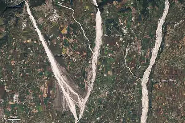
Three of northeastern Italy's rivers, the Cellina, Meduna and Tagliamento can be seen in this image taken on Sept. 21 by NASA's Landsat 5 satellite, as they flow toward the Adriatic Sea.
The gravel-coated riverbeds contrast sharply with the surrounding landscape, highlighting the river contours.
The rivers are fed by tributaries from nearby mountains. They then flow over a coastal floodplain that is densely packed with crops and settlements.
Latest Videos From
As the mountain basin upstream from the three rivers is seismically active and prone to landslides , lots of sediment can reach and build up in these rivers. The braided channels of the three rivers are indications of such loads. Rivers that receive more sediment than they can move effectively are often carved into braided channels as the sediment changes the river's shape.
In addition, heavy rain showers occur in the area, which also contribute to the sediment build-up in the rivers. The region north of these rivers gets as much as 120 inches (300 centimeters) of rain a year making it one of the wettest places in Italy. These showers erode the landscape, causing significant quantities of mud and debris to flow into the rivers, making them prone to flooding.
Around the rivers, rectangular shapes of green, gold and brown belong to cultivated fields. The crops mingle with settlements, some of which are quite close to river channels. Hydrologists have expressed concern about continued development on this floodplain because flood damage occurs so frequently.