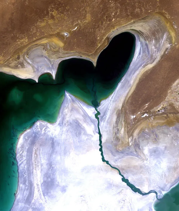
This satellite image, from July 24 features the heart-shaped Small Aral Sea, also known as the North Aral Sea.
The Aral Sea was once the world's fourth-largest inland body of water, but since the rivers that fed it were diverted for irrigation projects 50 years ago, it has been steadily shrinking.
By the end of the 1980s, little water was reaching the lake causing it to split into two sections: the Small Aral Sea to the north in Kazakhstan and the Large Aral Sea to the south, shared by Kazakhstan and Uzbekistan. By 2000, the Large Aral Sea had split into an eastern and western lobe. The eastern lake vanished last year.
Latest Videos From
Five years ago, a dam was built between the sea's northern and southern sections to help improve water resource management and reverse the man-made environmental disaster. The dam allowed the river to feed the northern Aral, which has visibly begun to recover, but did nothing for the southern section, which is expected to dry out completely by 2020.
The white area surrounding the lakebed is a vast salt plain now known as the Aralkum Desert, a result of the sea's evaporation. The desert is a roughly 15,444-square-mile (40,000-square-kilometer) zone of dry, white salt and mineral terrain.
In addition, each year violent sandstorms pick up at least 150,000 tons of salt and sand from Aralkum and transport them across hundreds of miles, causing severe health problems for the local population and altering the region's climate.

 Live Science Plus