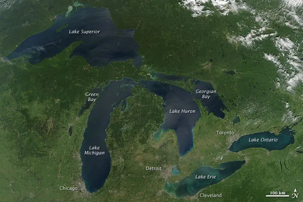
Late August 2010 provided a rare satellite view of a cloudless summer day over the entire Great Lakes region.
Open water appears blue or nearly black in an image taken by NASA's Aqua satellite. The pale blue and green swirls near the coasts of the lakes are likely caused by algae or phytoplankton blooms or by calcium carbonate the material marine organisms use to form their shells from the lake floor.
The Great Lakes comprise the largest collective body of freshwater on the planet, containing roughly 18 percent of Earth's water supply and 90 percent of the United States'. Only the polar ice caps contain more fresh water. In fact, if all the water from the Great Lakes was spread over the 48 contiguous states, the water would still be around 9.5 feet (2.9 meters) deep.
Latest Videos From
The lakes cover more than 94,000 square miles (240,000 square kilometers); they're such a large feature of the planet that if you stood on the moon, you would still be able to see them.
The region around the Great Lakes basin is home to more than 10 percent of the population of the United States and 25 percent of the population of Canada.
Between the United States and Canada, there are 10,900 miles (17,549 km) of Great Lakes coastline. Their entire combined shoreline is equal to almost 44 percent of the circumference of the Earth. Michigan alone has 3,288 miles (5,294 km) of coastline along the lakes, giving it more coastline than any other state, except for Alaska.

 Live Science Plus