Oklahoma's Eroded Mountains
Get the world’s most fascinating discoveries delivered straight to your inbox.
You are now subscribed
Your newsletter sign-up was successful
Want to add more newsletters?
Delivered Daily
Daily Newsletter
Sign up for the latest discoveries, groundbreaking research and fascinating breakthroughs that impact you and the wider world direct to your inbox.
Once a week
Life's Little Mysteries
Feed your curiosity with an exclusive mystery every week, solved with science and delivered direct to your inbox before it's seen anywhere else.
Once a week
How It Works
Sign up to our free science & technology newsletter for your weekly fix of fascinating articles, quick quizzes, amazing images, and more
Delivered daily
Space.com Newsletter
Breaking space news, the latest updates on rocket launches, skywatching events and more!
Once a month
Watch This Space
Sign up to our monthly entertainment newsletter to keep up with all our coverage of the latest sci-fi and space movies, tv shows, games and books.
Once a week
Night Sky This Week
Discover this week's must-see night sky events, moon phases, and stunning astrophotos. Sign up for our skywatching newsletter and explore the universe with us!
Join the club
Get full access to premium articles, exclusive features and a growing list of member rewards.
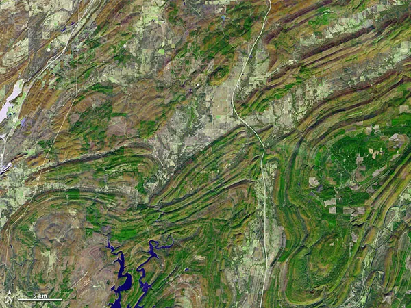
Oklahoma is known for its miles of flat prairie, but the state also has a very old, eroded mountain range, called the Ouachita Mountains, which formed over 300 million years ago.
These mountains are highly eroded remnants of a much larger range, one that may have once stretched from Texas into southeastern Canada.
On Nov. 13, 2002, NASA's Terra satellite captured this image of the eroded mountain remnants. This picture combines infrared, red and green wavelengths of light, to create an image that is basically true to color. The mountains form various patterns with their long, folding contours. Low-lying areas between the slopes are home to bodies of water, crops, towns and roads.
The Ouachita Mountains extend through west central Arkansas, southeastern Oklahoma and north-east Texas. Along with the Ozark Mountains, the Ouachita Mountains form the United States' Interior Highlands, the only major mountainous region between the Rocky Mountains and the Appalachian Mountains.
The mountains have a geologic history spanning hundreds of millions of years. Long before the first dinosaur evolved, the southern central United States sat at the bottom of an ancient sea. Starting around 340 million years ago, the supercontinent of Pangaea was formed, and resulting tectonic collisions thrust the ancient sea floor skyward to form a massive mountain range. The similarities between rock layers of the Ouachita Mountains and the Appalachian Mountains indicate that they were part of the mountain range formed by this collision.
About 200 million years ago, Pangaea began to break apart. The breakup wrenched apart the supersized mountain range, leaving a wide swath of low-lying land between the Ouachita Mountains in the west and the Appalachian Mountains in the east. Low-profile land persists today across much of the southeastern United States.
- The World's Tallest Mountains
- Infographic: Tallest Mountain to Deepest Ocean Trench
- Epic Past of Highest Coastal Mountain Uncovered
Get the world’s most fascinating discoveries delivered straight to your inbox.

