
Fall Foliage Seen from Space
Fall's Early Start
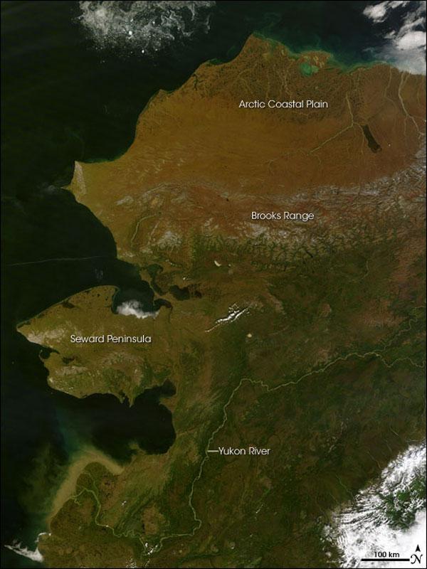
As fall officially begins with the coming autumnal equinox tomorrow (Sept. 22) at 11:09 p.m. EDT (8:09 p.m. PDT), different parts of the country will start to see more signs that fall is finally here, as leaves on trees begin to change color from their summer green to brilliant yellow, oranges and reds.
This hallmark of the changing seasons begins at different points in different places, with more northerly areas tending to see a riot of arboreal color earlier than southern areas. (In the above image, leaves have already started to change by late August in Alaska.)
Where forests are thick enough, the medley of colors can even be seen by satellites and astronauts in space.
Autumn in Alaska
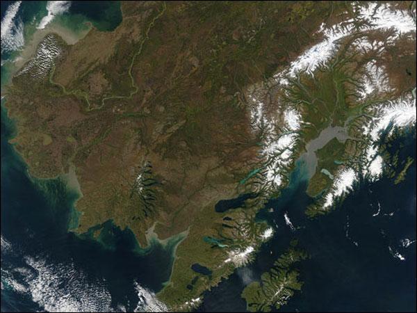
A rare clear view of the state of Alaska on Sept. 14, 2003, reveals a landscape already transitioning to fall, though the actual date of the fall equinox that year was a week away.
The state is swathed in reddish browns, golds and greens as summer's lushness fades. Scattered across the landscape are several dark brown patches that mark the location of fire-scarred terrain.
In the upper left corner of the image taken by NASA's Aqua satellite, the Yukon River flows down from the north as a bright green ribbon, emptying sediment and other organic matter into Norton Sound. Right of center, Cook Inlet is colored gray by fine glacial silt brought in by the Susitna River and its tributaries. Snow-covered mountain ranges, including the Alaska Range to the north, surround the Inlet. At bottom, to the right of center, is Kodiak Island.
Autumn's Head Start
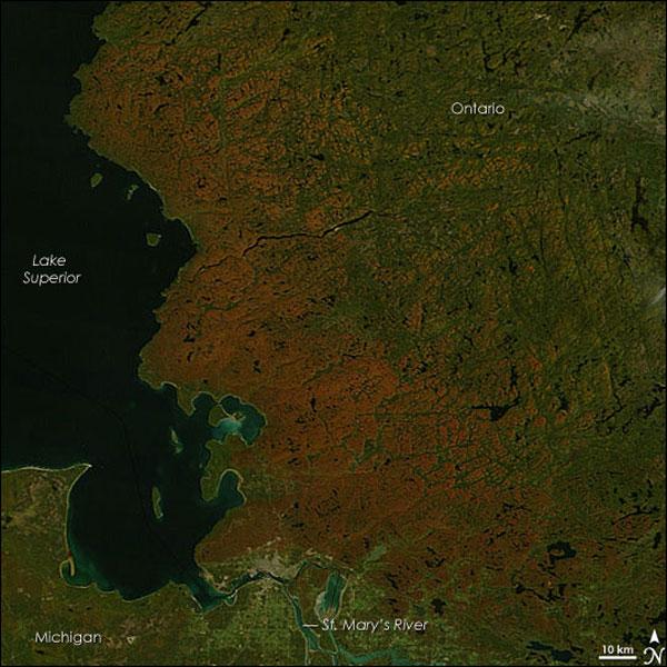
The calendar may have set September 23 as the first day of autumn in 2007, but the forests that line the eastern shore of Lake Superior had already started to mark the turning of the season when NASA's Terra satellite snapped this image.
In the picture, the forests of northern Michigan and southern Ontario flamed orange as the first trees of the season maples began to display their brilliant red and orange fall colors. Veins of green run through the sea of orange where the deciduous forest gives way to deep green pine trees.
The most vivid color is concentrated in Canada's province of Ontario. Located farther south, Michigan's trees show only a hint of color.
The St. Mary's River seems to be the dividing line between the brightest colors and the as-yet-unchanged forest. The river is also the border between the United States and Canada, as well as the only waterway linking Lake Superior to the rest of the Great Lakes .
Maples and Aspens Color Wasatch Range
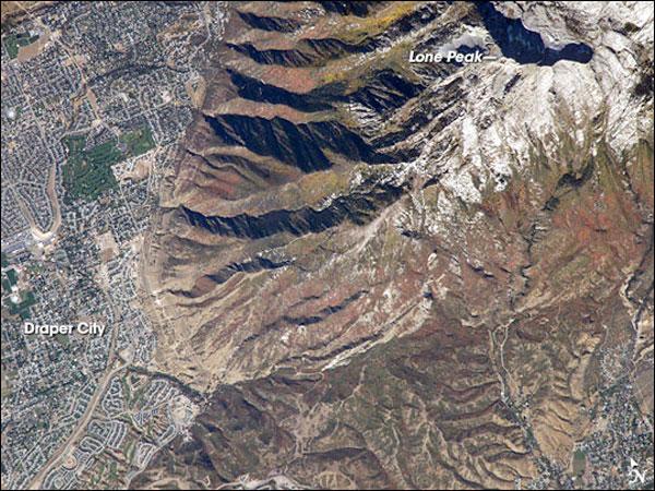
The cooling days of autumn find the Wasatch Range clothed in the leaves of deciduous trees turning color.
This astronaut photograph, taken at the end of September, captures red- (maple trees) and gold-mantled (aspen trees) hill slopes along the western mountain front to the south of Salt Lake City.
The Wasatch Range, a frequent destination for hikers, backpackers and skiers, is considered to be the westernmost part of the Rocky Mountains, and rises to elevations of approximately 12,000 feet (3,600 meters) above sea level. The elevation of Lone Peak, visible at upper right, is approximately 11,253 feet (3,410 m).
Canada's Creeping Fall Colors
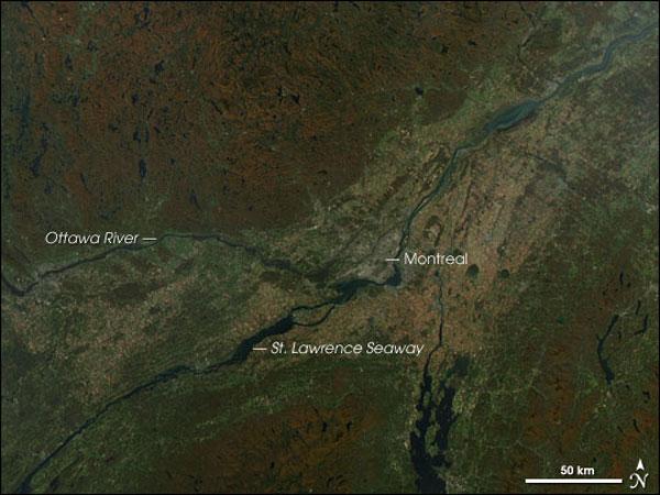
In this image from NASA's Aqua satellite taken on Oct. 6, 2005, fall is creeping down toward Montreal, Canada, from the surrounding higher elevations. The reddish-brown of fading forests is replacing summer's green.
Although the land in the valley between the Ottawa River and the St. Lawrence Seaway still displays quite a bit of green, some golden areas have appeared as well.
To the south, autumn has turned the Adirondack (bottom center) and Green Mountains (bottom right) a brilliant reddish brown. To the north, the lake-dotted expanse of Quebec province has turned color as well.
Fall Leaves on Full Display

New England's fall colors were on full display on a clear October morning when astronauts aboard the International Space Station snapped this image.
The fall foliage of Baxter Woods Park in Portland, Maine, shows the reds and browns of a mix of trees, including maple, old-growth white oaks and hemlock. Nearby Evergreen Cemetery is highlighted by the brilliant red and yellow leaves of maple trees.
Surrounded by the cityscape of Portland, the wooded cemetery is known for both historic headstones and wooded trails.
Fall Colors Sweep Through Northeast
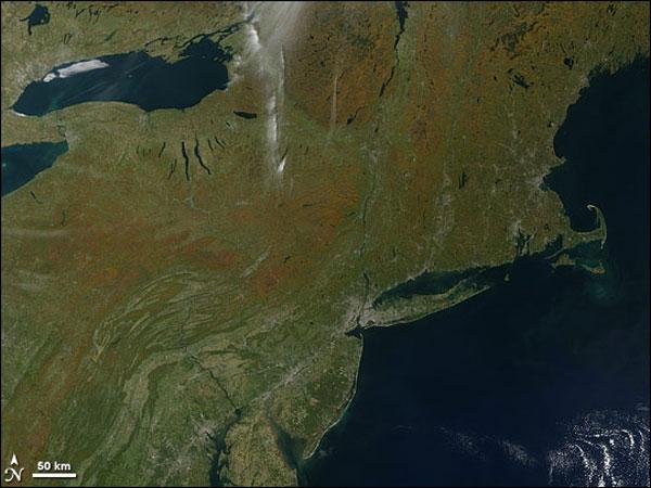
Fall was beginning to color the East Coast of the United States when NASA's Terra satellite captured this image on Oct.12, 2008.
Orange touches trees in the north and at higher elevations, where temperatures are cooler. Lower elevations are still green.
The fall color follows the sweep of the Appalachian Mountains through Pennsylvania, New York and into New England.
Get the world’s most fascinating discoveries delivered straight to your inbox.
Appalachian Autumn
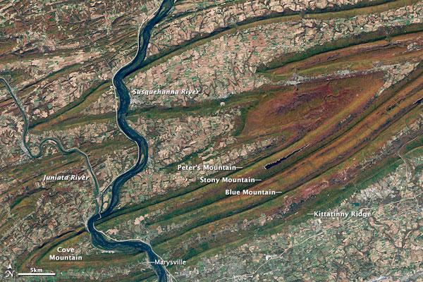
The trees along the ridge line of the Appalachian Mountains in central Pennsylvania are a riot of gold, orange and red leaves, hinting that the coolness of autumn had settled over the region by Oct. 21, 2001, when this image was snapped by NASA's Landsat satellite.
At lower elevations, though, the trees remained dark green.
Also seen in the image is the Susquehanna River system. The river flows generally south from its headwaters in upstate New York to the Chesapeake Bay. Located north of Harrisburg, Pa., which is just below the lower edge of the image, the region is called the Susquehanna Water Gap.
Fall Leaves Fade
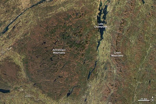
By November, the flame of red and orange that painted the forested mountains of the northeastern United States in the autumn has faded into subdued shades of orange and brown. The fall leaf season is coming to an end.
This true-color image of the Adirondack and Green Mountains was captured by NASA's Aqua satellite on Nov. 8, 2009. The mountains are brown, the farmed valleys, gold.
Veins of green evergreen forest are visible throughout the mountains now that the leaves of the surrounding deciduous forest are gone.

