It's quick and easy to access Live Science Plus, simply enter your email below. We'll send you a confirmation and sign you up for our daily newsletter, keeping you up to date with the latest science news.
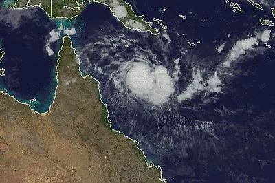
Tropical Cyclone Zane formed in the Coral Sea to the northeast of Queensland on Monday and quickly strengthened during the next 24 hours.
Zane currently has tropical storm-force sustained winds but is expected to strengthen further as it approaches the Cape York Peninsula of Queensland Tuesday night into Wednesday.
Winds could reach the equivalent of a Category 2 hurricane before landfall with maximum winds approaching 100 mph (160 kph).
Landfall is expected across the northern half of the Cape York Peninsula, Wednesday night, local time. The main threats will be damaging winds at and near the coast along with flooding rains which can cut some of the small towns of the region off for several days.
The satellite image above shows Zane off the coast of Queensland Tuesday night, local time.
Zane is expected to remain a tropical cyclone, although in a weaker state as it moves farther west into the Gulf of Carpentaria later in the week.
Sign up for the Live Science daily newsletter now
Get the world’s most fascinating discoveries delivered straight to your inbox.
At this point, it appears Zane will likely lose its tropical cyclone status before making another landfall, but enhanced rainfall could lead to some flooding potential across northern third of Northern Territory late in the week.
The weather is getting stranger, right? Well, for the most part no, scientists say, but humans often think so when a strange event does occur. So here’s your chance to prove how much you known about weather oddities.

 Live Science Plus