
 Live Science Plus


Minneapolis, Chicago May Receive Biggest Snow of Season
This article was provided by AccuWeather.com.
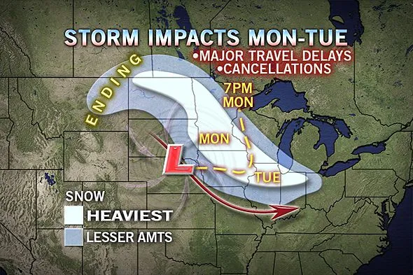
A winter storm will spread a swath of heavy snow from the Dakotas to the Ohio Valley early this week.
This is the same winter storm which could bring significant snow to Washington D.C. and Baltimore metro areas with dangerous coastal flooding along the East Coast Wednesday into Thursday.

This storm, which has already brought accumulating snow to the northern Rockies and rain showers as far south as San Francisco and Salt Lake City, ejected out into the Plains Sunday night.
Steady snow developed across eastern Montana through northern Iowa, with accumulations beginning in Bismarck, Fargo, and Watertown, S.D.
Snow will continue eastward, spreading into Minneapolis, Eau Claire, and Chicago during the day Monday into Monday night.
Snow will begin toward the evening rush hours in Chicago, which could lead to hazardous road conditions developing while millions are traveling home.
Get the world’s most fascinating discoveries delivered straight to your inbox.
The heaviest snow in the corridor from Minneapolis to Chicago is then expected Monday night into Tuesday morning with snowfall rates of up to 1 inch per hour. This will lead to significant travel problems across I-35, I-43, I-90, I-29, and I-94.
AccuWeather.com Meteorologists are expecting snowfall accumulations on the order of 6-12 inches from Fargo, N.D. through Minneapolis, Minn. through the southern suburbs of Chicago.
Minneapolis would need an accumulation of nearly a foot to surpass their biggest storm of the season, which was the 10.5 inches that fell way back on December 9th.
In the city of Chicago, approximately 6 inches of snow accumulation is expected through Tuesday with lesser amounts to the north toward Racine and Milwaukee, Wisc. An accumulation of 6 inches would surpass the biggest storm of the season in Chicago, which to date is 5.4 inches that fell Feb. 26th-27th.
Snow will spread farther to the east on Tuesday, bringing accumulations to Indianapolis, Fort Wayne and Toledo.
6+ inches of snow is likely Tuesday into Tuesday night from the northern suburbs of Indianapolis to near Gary with a corridor of 3-6 inches as far north as Kalamazoo, Mich. and Toledo, Ohio.
Moderate snow accumulations will then streak through central Ohio into the central Appalachians Tuesday night into Wednesday before our attention turns to the mid-Atlantic part of the country.
AccuWeather.com Meteorologists will continue to update this story and our forecasted snow amounts as this storm takes shape across the Plains tonight into Monday. Any slight fluctuation in the track of the system could mean the difference between heavy, travel disrupting snow or nuisance, lighter amounts.
Check back with AccuWeather.com and also click over to our Winter Weather Center for a larger version of our latest snowfall forecast map.
© AccuWeather.com. All rights reserved. More from AccuWeather.com.
The weather is getting stranger, right? Well, for the most part no, scientists say, but humans often think so when a strange event does occur. So here’s your chance to prove how much you known about weather oddities.
Weird Weather: One Strange Quiz
