













Small Earthquake Hits Nevada

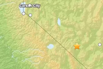
An earthquake of preliminary magnitude 3.9 struck today near the Nevada-California border, according to the U.S. Geological Survey (USGS).
The temblor's epicenter was 43 miles (69 km) west of Tonopah, Nev., and 122 miles (196 km) southeast of Carson City. It originated 8 miles (12.9 km) deep and struck at 7:29 a.m. local time (1029 UTC), the USGS reports.
There was some weak to moderate shaking in the area, according to the USGS, and no immediate reports of damage.
Earthquakes of this size tend to be felt by people in the area but typically do not cause significant damage, other than possibly broken windows and falling dishes or the toppling of unstable objects. But the damage caused by any single event depends on the quake's depth, proximity to populated areas, building standards in the region, as well as the type of earthquake. The USGS frequently updates the magnitude of an event after more data is analyzed.
An earthquake's magnitude is a measure of the energy released at the source. It is just one predictor of the shaking that may ensue, which is affected by local and regional geology. Scientists know in a general sense what causes Earthquakes but are unable to predict specific quakes.
This article will be updated if significant additional information becomes available. Find more earthquake news here.
Get the world’s most fascinating discoveries delivered straight to your inbox.
