 Live Science Plus


Drought to Continue Despite Recent Storms
This article was provided by AccuWeather.com.
Despite recent storms during the autumn and first part of the winter, drought conditions are forecast to continue over a large part of the Plains.
Article continues belowHowever, unless there is a big turnaround later this winter and spring, more significant problems could be ahead for the Mississippi River above the Ohio River junction.
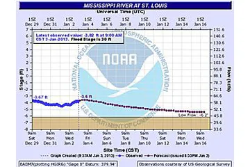
While a storm is forecast to swing northeastward over the Central states, much of the rain may fall south and east of St. Louis. Mississippi River levels are expected to dip again next week at St. Louis, according to National Weather Service hydrologists.
Levels at St. Louis were hovering under minus 3 feet on Jan. 3, 2013, and were projected to dip to below minus 5 feet during the weekend of Jan. 12-13, 2013. The record low level for the Mississippi River at St. Louis is minus 6.20 feet set on Jan. 16, 1940.
The U.S. Army Corps of Engineers has been taking steps to keep the shipping channel open by dredging the river bottom, removing rocky outcroppings and placing barriers under the water to minimize shifting silt. The rest is up to Mother Nature. Barge companies have been limiting their loads due to the low water levels.
Snow fell over part of the winter wheat belt with the storm just after Christmas 2012. However, much more moisture is needed through the winter and into the spring.

According to Agricultural Meteorologist Dale Mohler, "One of the big problems the Central states had last spring was a lack of thunderstorm complexes."
These groups of thunderstorms are the major source for spring rainfall and runoff over the Plains and Midwest, following melting snow early.
According to AccuWeather.com's Long Range Team of meteorologists headed by Paul Pastelok, "There are concerns for drought continuing over the central High Plains and the northern Plains in general going into the spring."
This area encompasses a large part of the watershed for the Missouri and upper Mississippi rivers.
Opportunities from rain and/or snow would increase moving southeastward from the Plains toward the Ohio Valley during the winter. However, an area of high pressure is likely to set up over the central Rockies and central High Plains.
Pastelok stated that the pattern does not look to be as dry of a start this spring, when compared to last year from Iowa to the Ohio Valley and some moisture is likely to make appearances over the southern Plains.
There is also some good news for the Southeast.
"Indications are that the drought/abnormally dry areas over Georgia and the Carolinas will shrink moving through the winter and should be mostly gone by the spring," Pastelok said.
Water levels were slowly rising on Lake Lanier, Ga., in recent days thanks to recent storms and reduced water releases. The reservoir is the major source of drinking water for the Atlanta metro area.
Large storm systems are projected by AccuWeather.com to sweep northeastward from the Gulf Coast toward the Ohio Valley, Appalachians and East Coast during much of the balance of the winter.
AccuWeather.com. All rights reserved. More from AccuWeather.com.
With much of the country experiencing an unseasonably warm winter, fears of climate change come to mind. See how well you understand recent weather, climate and the difference between them.
Weather vs. Climate Change: Test Yourself

