


Snowstorm, Blowing Dust for Four Corners
This article was provided by AccuWeather.com.
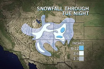
For the third time in a week, significant snowfall is on the way for parts of the Four Corners region.
Snow will spread across the Four Corners today and tonight with the heaviest amounts found across the San Juan Mountains of southwestern Colorado. Several inches of snow will blanket the bigger cities of the region such as Flagstaff, Durango and Grand Junction.
For Flagstaff, it will be their third significant storm since Friday. The city has received over 20 inches so far in December.
The snow is expected to wind down on Wednesday as the storm ejects into the Plains. However, strengthening winds will make blowing dust a concern across eastern New Mexico and the Texas Panhandle where dry weather will prevail. Winds can gust up to 60 mph in this region.
In the Denver area, the accumulating snow will fall between late tonight and tomorrow morning. Several inches of snow is expected.
Interstates across the Four Corners can be adversely affected by the snowstorm and any leftover snow on Wednesday can combine with high winds to create near white-out conditions.
Get the world’s most fascinating discoveries delivered straight to your inbox.
Specifically, I-40 in Arizona and I-70 in Utah are most vulnerable to nasty travel conditions through Wednesday morning.
Although there will be plenty of cold air to promote snow across most of the Four Corners, residents south of the storm's track can expect just light snow or even rain showers.
Rain showers will wet the ground in Phoenix tonight which has already experienced an unusually wet first half of December. Farther east, light snow can accumulate a coating to an inch in Albuquerque and Santa Fe.
Ski resorts will no doubt enjoy the dump of fresh powder. Locales in and around Salt Lake City can pick up several inches with more in the Wasatch Range to the south.

This moderate snow event across the Southwest will evolve into a full-fledged blizzard later on Wednesday afternoon through Thursday as the storm races into the Great Plains and Midwest.
In the wake of the the storm, a stretch of dry weather is expected into the pre-Christmas weekend.
AccuWeather.com. All rights reserved. More from AccuWeather.com.
The only sure thing about weather forecasts is that they’re wildly different all over the planet. Test your knowledge on the wild ranges in temperature, precipitation and more.
Extreme Weather Facts: Quiz Yourself
