It's quick and easy to access Live Science Plus, simply enter your email below. We'll send you a confirmation and sign you up for our daily newsletter, keeping you up to date with the latest science news.
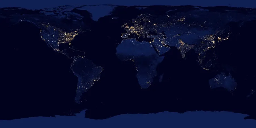
You may have seen Earth's lights from space — but never quite like this.
Today (Dec. 5), NASA and the National Oceanographic and Atmospheric Administration (NOAA) released a slew of images showing what the planet looks like when the sun goes down. The amazing images were announced in a news conference at the American Geophysical Union's annual meeting in San Francisco and were taken by an instrument aboard the Suomi NPP satellite in recent months.
"For all the reasons that we need to see Earth during the day, we also need to see Earth at night," said Steve Miller, a researcher at NOAA's Colorado State University Cooperative Institute for Research in the Atmosphere, in a NASA statement. "Unlike humans, the Earth never sleeps." [Black Marble Images: Earth at Night]
The satellite sensor, the day-night band of the Visible Infrared Imaging Radiometer Suite (VIIRS), is primarily intended to capture detailed data about cloud, snow and ice formations during nighttime hours. Before 1973, pictures of America's nighttime lights were classified by the military, but since then NOAA's National Geophysical Data Center has been processing the images to examine population and urbanization changes around the planet, along with helping to pinpoint electrical power blackouts in the United States.
The VIIRS instrument is sensitive enough to detect the nocturnal glow produced by Earth's atmosphere and the light from a single ship in the sea, according to the release.
The images show the entire Earth at night (which some have referred to as the "Black Marble"), as well as the United States and the Nile River. There is also a video that shows the sleeping Earth a-twirl.
This image of the continental United States at night is a composite assembled from data acquired by the Suomi NPP satellite in April and October 2012.
(Image credit: NASA Earth Observatory/NOAA NGDC)
On Oct. 13, 2012, the Visible Infrared Imaging Radiometer Suite (VIIRS) on the Suomi NPP satellite captured this nighttime view of the Nile River Valley and Delta.
For the science geek in everyone, Live Science offers a fascinating window into the natural and technological world, delivering comprehensive and compelling news and analysis on everything from dinosaur discoveries, archaeological finds and amazing animals to health, innovation and wearable technology. We aim to empower and inspire our readers with the tools needed to understand the world and appreciate its everyday awe.