It's quick and easy to access Live Science Plus, simply enter your email below. We'll send you a confirmation and sign you up for our daily newsletter, keeping you up to date with the latest science news.
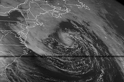
This Halloween marks the 21st anniversary of the "Perfect Storm," also known as the Halloween Nor'easter of 1991. In 1997 a novel based on the storm was written, which was then made in to an Oscar-nominated movie in 2000. They told the tale of the six Gloucester, Mass., fishermen who died at sea when the storm's massive waves (some of which reached 39 feet) capsized their boat. These pieces of pop culture have helped the notoriety of the storm, but what exactly was it that made the storm "perfect"?
According to AccuWeather Senior Expert Meteorologist Dan Kottlowski it was the combination of a tropical system (the remnants of Hurricane Grace) and a non-tropical system that created such a massive storm. The conditions had to come together just right for these systems to be able to feed off of one another the way that they did. Grace had weakened just enough so that it could be pulled in by the non-tropical system, but still contained enough deep moisture for it to feed into the cold. When tropical moisture is added to cold air in such a way it creates enormous amounts of energy, which leads to increased rain and wind.
This video from NOAA shows the storm as it moves across the Atlantic.
While these conditions are rare, this was not a one-time occurrence. The storm's iconic name and its popularity in film and literature have greatly helped make this storm stand out the most, but according to Kottlowski, storms from such conditions have occurred since then.
"It's rare for a tropical and a non-tropical system to join," he said, "but these conditions are favored this time of year. Late October to early November southern Atlantic waters are still warm enough for a tropical system, but cold air is already coming down from Canada. It's the right time for these systems to meet."
The Gale of 1878, for example, was created with similar conditions. In late October a tropical system moved out of the Keys northward along the East Coast, bringing 4.5 inches of rain to Cape Hatteras, N.C. By the time the storm reached Philadelphia it met with a cold air system. The result was hurricane force winds on Oct. 23 in the city and its surrounding areas, up to 72 miles per hour. Estimates gauge that from 500-700 buildings were destroyed.
Sign up for the Live Science daily newsletter now
Get the world’s most fascinating discoveries delivered straight to your inbox.
Now, AccuWeather.com meteorologists are monitoring Sandy for the potential of another such storm to occur next week. While there are still many possible paths for the storm to go, if it does move up the East Coast, paralleling Florida and the Carolinas, it could be drawn inland over the mid-Atlantic and New England again next week. As happened in 1991, heavy rains, wind, and storm surge could last for days. The difference this time could be the addition of heavy, wet snow covering the Appalachians as a result of the storm's location.
There is also the potential for this system to be far enough away from the coast that it actually pulls moisture away and creates sunny conditions instead. Follow AccuWeather.com's Hurricane Center for updates on the storm's path.
(Image credit: AccuWeather.com)
The technology for forecasting storms today is not that much different than it was in 1991. According to Kottlowski, the big difference now is what people know about utilizing the data that satellites bring in. While this same data was available in 1991, forecasters and researchers have made breakthroughs in their diagnostic formats so that storms can be detected and tracked better.
The only sure thing about weather forecasts is that they’re wildly different all over the planet. Test your knowledge on the wild ranges in temperature, precipitation and more.

 Live Science Plus