Our amazing planet.

Antarctic Ice Rift Growing, Satellite Images Show

Pine Island Glacier September 2012
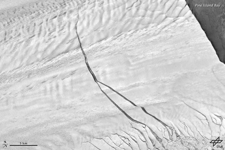
A massive crack in Pine Island Glacier is steadily growing, as seen in a Sept. 14, 2012, satellite image. (Image credit: NASA Earth Observatory)

The giant fissure that was discovered last year in Antarctica's Pine Island Glacier widened and lengthened in recent months, new satellite images show.

The 18-mile-long (29 kilometers) rift foretells the start of a giant iceberg, and researchers have been monitoring the glacier since the fissure was discovered in 2011. The giant fissure was stable for several months, but in May it spawned a second crack.

Ultimately, the berg that breaks off from the glacier could span 350 square miles (900 square km).

NASA scientists flying over Pine Island Glacier in a DC-8 airplane as part of their IceBridge mission first spotted the massive crack in the ice shelf on Oct. 14, 2011. The ice shelf extends into the Amundsen Sea, where ocean water melts it from below.

Pine Island Glacier birthed large icebergs in 2001 and 2007, but the 2011 NASA IceBridge survey marked the first time a major ice breakup was measured from the air.

This week NASA's IceBridge mission plans to return to Pine Island Glacier, weather permitting, to monitor the changes to the glacier and the process of the breakup. The scientists are halfway through their 2012 Antarctic campaign.

Follow OurAmazingPlanet on Twitter @OAPlanet. We're also on Facebook and Google+.

Live Science Staff
For the science geek in everyone, Live Science offers a fascinating window into the natural and technological world, delivering comprehensive and compelling news and analysis on everything from dinosaur discoveries, archaeological finds and amazing animals to health, innovation and wearable technology. We aim to empower and inspire our readers with the tools needed to understand the world and appreciate its everyday awe.