It's quick and easy to access Live Science Plus, simply enter your email below. We'll send you a confirmation and sign you up for our daily newsletter, keeping you up to date with the latest science news.
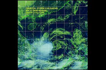
Tropical Storm Gaemi developed in the South China Sea on Sept. 29. Since then, it has meandered to the east, stalling just west of the Philippines before turning back to the west on a track toward Vietnam.
While being stalled near the Philippines, Gaemi led to flooding problems in the north and west, including the capital city of Manilla where more than 4 inches of rain fell earlier this week.
The flooding was severe enough to cancel afternoon classes as well as some flights at the international airport.
Gaemi now has its sights on Indochina where a landfall is expected along the central Vietnamese coastline on late Saturday or Saturday night.
Although this storm is not particularly strong, wind gusts over 60 mph will be possible along and near the coastline close to where Gaemi makes landfall. Landfall is expected near the cities of Tuy Hoa and Qui Hhon.
Gaemi will quickly move inland and weaken, thus reducing the threat for widespread damaging winds; however, flooding rainfall will be a threat from central Vietnam into southern Laos, Cambodia and Thailand through Monday.
Sign up for the Live Science daily newsletter now
Get the world’s most fascinating discoveries delivered straight to your inbox.
The Western Pacific Basin has been active with tropical systems the past several weeks, and that trend is not changing anytime soon, as another tropical system is expected to form to the east of the Philippines over the weekend.
If this tropical system does in fact develop, it could have potential impacts on areas from the Philippines to Japan, so all interests in these areas should monitor this disturbance.
The only sure thing about weather forecasts is that they’re wildly different all over the planet. Test your knowledge on the wild ranges in temperature, precipitation and more.

 Live Science Plus