


Typhoon Sanba Threatens Okinawa; Korea Next
This article was provided by AccuWeather.com.
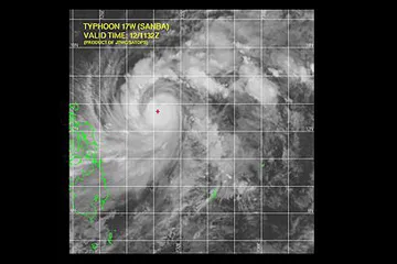
Typhoon Sanba poses a growing threat to southwestern Japan and South Korea.
As of Wednesday, Sanba had strengthened from a moderate tropical storm to a typhoon equivalent to a Category 1 hurricane, according to The Joint Typhoon Warning Center (JTWC).
Sanba is churning over the southern Philippines Sea, to the north and east of the Philippines, in an environment favorable of further strengthening. Very warm water will help to fuel the strengthening, perhaps into a major typhoon.
Movement to the north and northwest is expected to continue through at least Saturday.
The projected path brings Sanba over or close to Okinawa, Japan, by Sunday, local time. While the island is well-prepared for typhoons, damage, power outages and flooding are likely in this scenario.
Okinawa endured a hard hit from Typhoon Bolaven in August and a previous blow from Haikui.
Get the world’s most fascinating discoveries delivered straight to your inbox.
Even well ahead of Sanba, moisture from the typhoon will meet with a stalled front draped across South Korea. Several inches of rain may deluge southeastern areas before the typhoon approaches the Korean Peninsula a couple of days after nearing Okinawa.
Rainfall of 1-2 feet is not out of the question, especially in mountainous terrain of South Korea.
"The worst case scenario is a widespread flooding disaster," AccuWeather Expert Senior Meteorologist Jim Andrews said.
Rainfall since July has been well above normal across portions of South Korea. Seoul, the capital and largest city of South Korea, has received nearly 40 inches (1 meter) of rain since July.
Keep checking back for the latest with AccuWeather.com.
Content contributed by AccuWeather Expert Senior Meteorologist Jim Andrews.
© AccuWeather.com. All rights reserved. More from AccuWeather.com.