
 Live Science Plus


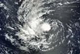
As Hurricane Igor flirted with Category 5 status today (Sept. 13), coming just 6 mph (7 kph) shy of the title reserved for the highest and most dangerous storm level on the five-tier Saffir-Simpson intensity scale.
In order to be considered a Category 5 hurricane, a storm must have sustained winds stronger than 155 mph (249 kph), according to the National Hurricane Center (NHC). Approaching Bermuda at 13 mph (21 kph), Hurricane Igor had sustained winds of 150 mph (241 kph) as of Monday morning – with the NHC warning the storm has a 40-percent chance of intensifying to a Category 5 over the next 48 hours.

Considering that an average Atlantic hurricane season sees nearly 10 named storms (tropical storms and hurricanes) and nearly 6 hurricanes, why are Category 5 hurricanes so rare?
The atmospheric circumstances that brew these massive storms have to be perfectly aligned, and mega-hurricanes only manage to make it to the states once in a blue moon.
Storm forming conditions
In the Atlantic, hurricane season lasts from June 1 to Nov. 30, with the peak season happening from mid-August to late October, according to FEMA. Most of these hurricanes do not get close enough to land to cause major damage, instead staying far out over the Atlantic Ocean.
Most hurricanes that hit the United States get their start in the Caribbean or the Atlantic, with many of the worst storms beginning their journeys off the coast of Africa. These low-pressure systems move westward off the west coast of Africa, where they are fueled by evaporating water vapor from the warm ocean surface. Storm clouds and rain form as evaporation cools the ocean's surface.
Luckily for us, wind shear often carries away a developing storm's heat, preventing a severe storm in the process. Wind shear is a change in the wind's speed or direction over a short vertical distance within the atmosphere, according to the NHC. The result helps to form eddies in the air, or turbulence.
When wind shear is low, it is unable to disrupt a growing storm's circulation. For example, using storm images and data, NASA was able to calculate that vertical wind shear decreased over the Caribbean Sea and tropical Atlantic Ocean from 20 knots (23 mph) to 10 knots (12 mph) over the last few days and helped make Igor stronger.
Low wind shear causes heat to build up (since there's not a lot of wind brushing across the sea surface and wicking away heat), low-pressure systems to form, and winds to begin to spiral inward toward the storm's center (the warmest air is in the eye of the hurricane), driving more showers and thunderstorms.
But finding wind shear low enough and waters warm enough to fuel a massive storm in the same area of the ocean basin can be relatively rare, meaning Category 5 storms are considerably fewer in number than simple tropical storms.
Category 5 and higher?
The United States gets so few Category 5 hurricanes, because most tropical storms are unable to keep up their 150-plus mph winds and lose much of their gust by the time they reach our shores, according to the NHC. Category 5 hurricanes also need water temperature to be above 80 degrees Fahrenheit (26.5 Celsius) in order to form, which is why heavy storms develop and thrive much more often in tropical climates but dissipate in cooler waters closer to the coast.
Only three Category 5 storms have ever made landfall in the United States: the Florida Keys Labor Day Hurricane that tore through the Keys in 1935, killing 408 people; Hurricane Camille, which struck along the Mississippi coast late on Aug. 17, 1969, killing 256 people and causing $1.421 billion in damage; and 1992's Hurricane Andrew, the most damaging storm in U.S. history until Hurricane Katrina, which destroyed swaths of south Florida.
Some scientists argue that major hurricanes will become more common in a warming world and that hurricanes could become even stronger, necessitating a new highest category, Category 6.
Category 5 on the Saffir-Simpson hurricane scale has no upper bound, on paper. But in 2006, Hurricane Wilma had top winds of 175 mph. An extrapolation of the current scale suggests that if a Category 6 were there, it would be in the range of 176-196 mph.
But some scientists say creating a Category 6 hurricane slot is unnecessary because the scale was designed to measure the amount of damage inflicted by winds, and beyond 156 mph, the damage begins to look about the same.
- A History of Destruction: 8 Great Hurricanes
- Could New York City Handle a Hurricane?
- Image Gallery: Hurricanes from Above
This article was provided by Life's Little Mysteries, a sister site to LiveScience.