 Live Science Plus


You are now subscribed
Your newsletter sign-up was successful
Want to add more newsletters?

Delivered Daily
Daily Newsletter
Sign up for the latest discoveries, groundbreaking research and fascinating breakthroughs that impact you and the wider world direct to your inbox.

Once a week
Life's Little Mysteries
Feed your curiosity with an exclusive mystery every week, solved with science and delivered direct to your inbox before it's seen anywhere else.

Once a week
How It Works
Sign up to our free science & technology newsletter for your weekly fix of fascinating articles, quick quizzes, amazing images, and more

Delivered daily
Space.com Newsletter
Breaking space news, the latest updates on rocket launches, skywatching events and more!

Once a month
Watch This Space
Sign up to our monthly entertainment newsletter to keep up with all our coverage of the latest sci-fi and space movies, tv shows, games and books.

Once a week
Night Sky This Week
Discover this week's must-see night sky events, moon phases, and stunning astrophotos. Sign up for our skywatching newsletter and explore the universe with us!
Join the club
Get full access to premium articles, exclusive features and a growing list of member rewards.
This article was provided by AccuWeather.com.
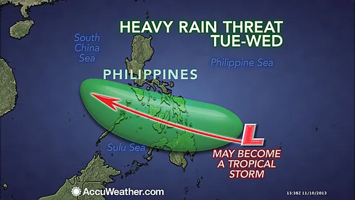
In the wake of once-Super Typhoon Haiyan, another tropical disturbance will impact the same areas left devastated across the Philippines by Haiyan Tuesday through Wednesday.
Even a causal passing shower or thunderstorm would dampen and hinder the recovery. But the danger of another tropical threat with heavy rains looms through midweek.
A tropical disturbance spinning a couple-hundred miles southeast of Palau is expected to track through the Philippines. While the exact track of the disturbance will be slightly to the south of Haiyan's, heavy rain accompanying the disturbance will pass directly over the areas devastated by Haiyan.
As the center of the disturbance reaches the Philippines by early Wednesday (local time), the system will likely develop into a tropical depression. Through late Wednesday, the system will cross the islands.
This system will not be traveling as fast as Haiyan, meaning there will be more time for heavy rain to pour down. Rain is expected to start late Tuesday afternoon (local time), and continue through Wednesday night.
AccuWeather.com Meteorologist Eric Wanenchak anticipates a general 100 to 200 mm (4 to 8 inches) of rain will fall along the path of the system.
That amount of rain could easily trigger new flash flooding problems, especially with the ground severely saturated by Haiyan. Mudslides are again a threat, while any rain could hamper cleanup and recovery efforts.
RELATED: Haiyan, Strongest Cyclone of the Year, Pounds the Philippines AccuWeather Hurricane Center Philippines Weather
The good news is that winds within the system will be significantly weaker than in Haiyan when it reaches the Philippines.
While the winds will pale in comparison to Haiyan, strong wind gusts of 65 to 80 kph (40 to 50 mph) could toss around debris left in the wake of Haiyan and create additional hazards to those who were left stranded and homeless this past week.
The bad news is that there is still potential for the disturbance to strengthen into a tropical storm and unleash the heavy rain.
This story was originally published on Friday, November 8, 2013, with content contributed by AccuWeather.com Meteorologists Eric Leister and Courtney Spamer.
© AccuWeather.com. All rights reserved. More from AccuWeather.com.
With much of the country experiencing an unseasonably warm winter, fears of climate change come to mind. See how well you understand recent weather, climate and the difference between them.
Weather vs. Climate Change: Test Yourself

