Rising sea levels are transforming the Florida Everglades, a new study shows. Plant communities that thrive in salt water are expanding along the coast, leaving less room for plants that depend on fresh water.
Salt-loving mangroves in the Everglades have marched inland in the past decade, while freshwater plants — such as saw grass, spike rush and tropical hardwood trees — lost ground, according to a study published in the October 2013 issue of the journal Wetlands.
The findings, which come from an analysis of satellite imagery from 2001 through 2010, match long-term trends tracked on the ground for the past 70 years, said lead study author Douglas Fuller, a geographer at the University of Miami.
Latest Videos From
"I was very surprised at how well the results matched our understanding of long-term trends and field data," Fuller said in a statement. "Normally, we don't see such clear patterns."
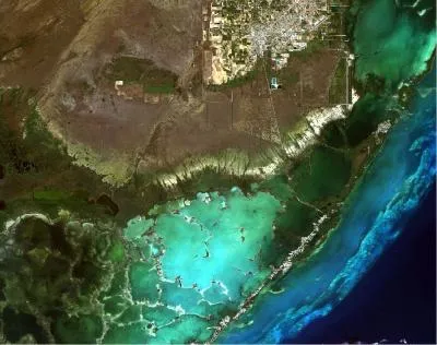
Satellite imagery of the southern Everglades — a region that includes Florida City, Key Largo and the upper Keys — revealed large patches of freshwater vegetation loss within 2.5 miles (4 kilometers) of the coast. Only freshwater plants in the interior, about 5 miles inland (8 km), showed growth trends, the researchers found.
Tracking growth and plant loss is an important part of ongoing restoration efforts in the Everglades. Changes in water management, such as the implementation of the Comprehensive Everglades Restoration Plan, may help offset the potential effects of saltwater intrusion, the researchers said. "However, restoration may not suffice if sea level rise accelerates in the coming decades," Fuller said.
The Everglades are one of the largest wetlands in the world. Water flows from north to south through a sea of grass underlain by cavernous limestone. In the past 200 years, about half of the original wetlands have disappeared.
Email Becky Oskin or follow her @beckyoskin. Follow us @livescience, Facebook & Google+. Original article on LiveScience.