It's quick and easy to access Live Science Plus, simply enter your email below. We'll send you a confirmation and sign you up for our daily newsletter, keeping you up to date with the latest science news.
Pine Island is one of the fastest-changing glaciers on the West Antarctic Ice Sheet, accounting for about 20 percent of the ice sheet's total ice flow to the ocean. The immense glacier is also one of least stable, quickly retreating and losing massive amounts of ice.
Pine Island Glacier - Jan. 24, 2017
(Image credit: Jesse Allen/ NASA Earth Observatory)
The Landsat 8 satellite captured this image of the latest iceberg event, showing the initial crack along the Pine Island Glacier's ice front.
Iceberg Breaks off of Pine Island Glacier
(Image credit: Jesse Allen/ NASA Earth Observatory)
This latest iceberg is between 0.6 and 1.2 miles (1 to 2 kilometers). Though smaller than previous icebergs, the calving event shows how fragile the ice shelf is, according to NASA scientists.
On July 8, 2013, a huge piece of the glacier's ice shelf (the portion that floats on the water) broke off to form a new iceberg. Here the floating part of the Pine Island Glacier can be seen just before the first crack appeared. The flow direction is from the lower right corner to the upper left one. One can see the ice in bright colors, the ocean's surface in darker ones.
Pine Island Glacier - Oct. 13, 2011
(Image credit: DRL.)
This is the first TerraSAR-X-shot that shows the narrow crack in its center. At that time the crack measured 15 miles (24 kilometers) in length and was 164 feet (50 meters) wide at its widest point.
Pine Island Glacier - April 13, 2012
(Image credit: DRL.)
The crack has been growing. Its edges now are up to 540 meters apart and it is 28 kilometers long. At the upper end of the crack one can see some overturned icebergs.
Pine Island Glacier - May 11, 2012
(Image credit: DRL.)
A second crack produced an iceberg that is 30 square kilometers large and enclosed by the bigger iceberg, which is still attached to the ice shelf.
Sign up for the Live Science daily newsletter now
Get the world’s most fascinating discoveries delivered straight to your inbox.
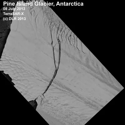
Pine Island Glacier - July 8, 2013
(Image credit: DLR)
On the left hand side the newly formed iceberg with the a size of 720 square kilometres is visible.
Pine Island Glacier overview
(Image credit: DLR.)
The combination of several satellite images gives an overview of the glacier (red outline). The flow direction (yellow) and the position of the crack (green) are implemented.
Map of Pine Island Glacier, Antarctica
(Image credit: Angelika Humbert, Alfred Wegener Institute.)
Topographic map of Antarctica. The Pine Island Glacier is marked in red.
For the science geek in everyone, Live Science offers a fascinating window into the natural and technological world, delivering comprehensive and compelling news and analysis on everything from dinosaur discoveries, archaeological finds and amazing animals to health, innovation and wearable technology. We aim to empower and inspire our readers with the tools needed to understand the world and appreciate its everyday awe.

 Live Science Plus