Get the world’s most fascinating discoveries delivered straight to your inbox.
You are now subscribed
Your newsletter sign-up was successful
Want to add more newsletters?
Join the club
Get full access to premium articles, exclusive features and a growing list of member rewards.
An account already exists for this email address, please log in.
Scientists create new map showing ice-free Antarctica in more detail than ever before
Bedmap3 is the most fine-grain map to date of the landscape beneath Antarctica's ice. Scientists created it using more than 60 years' worth of data from satellites, ships and dog-drawn sleds.
Scientists have unveiled the most detailed map yet of the landscape hidden beneath Antarctica's ice.
The high-resolution map reveals what the frozen continent looks like beneath its miles-thick blanket of ice and snow, and will help researchers predict how Antarctica might evolve in a fast-warming climate.
"Imagine pouring syrup over a rock cake [or a chocolate chip cookie, if that's more familiar to you] — all the lumps, all the bumps, will determine where the syrup goes and how fast," Hamish Pritchard, a glaciologist at the British Antarctic Survey (BAS) and the lead author of a new study outlining the research, said in a statement.
The same process will occur in Antarctica if a significant amount of the ice sheet melts, Pritchard said. "Some ridges will hold up the flowing ice; the hollows and smooth bits are where that ice could accelerate," he said.
Bedmap3 builds on two previous studies that digitally stripped Antarctica of its ice. The new map incorporates all of the data used for Bedmap1 and Bedmap2 — including measurements gathered by planes, satellites, ships and even dog-drawn sleds. But the team also sourced an extra 52 million data points to refine these previous results, according to the study, published March 10 in the journal Scientific Data.
In total, more than six decades' worth of data was compiled to construct Bedmap3, the researchers said in the statement. "This is the fundamental information that underpins the computer models we use to investigate how the ice will flow across the continent as temperatures rise," Pritchard said.
Sign up for the Live Science daily newsletter now
Get the world’s most fascinating discoveries delivered straight to your inbox.
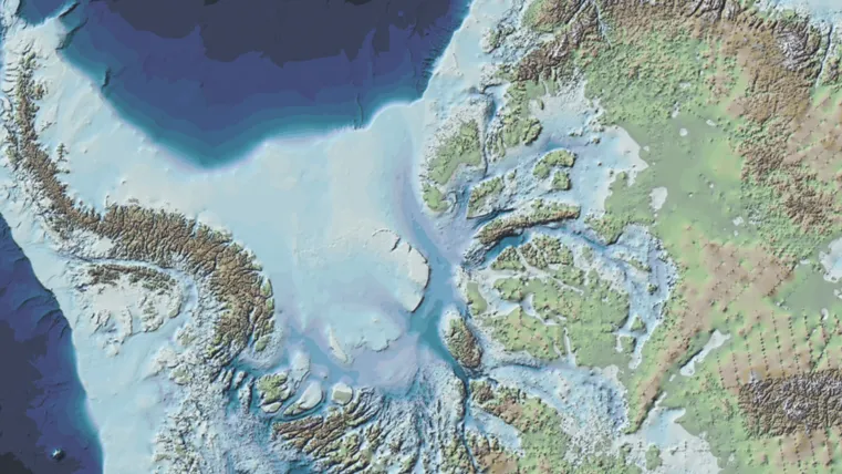
The new map is color coded to show the height of Antarctica's bedrock above sea level, highlighting the continent's tallest mountains and deepest valleys. The topography is revealed in the finest detail yet, providing new insight into understudied areas, including around the South Pole, according to the statement.
Bedmap3 shows the topography of Antarctica beneath the ice sheet.
(Image credit: Pritchard et al. Scientific Data (2025). Creative Commons.)
The researchers used radar, seismic and gravity measurements to map the bedrock and estimate the thickness of the ice sheet above it. Against their expectations, they found that the place with the thickest ice in Antarctica is an unnamed canyon in Wilkes Land, a district in the east of the continent.
Previous surveys placed Antarctica's thickest ice in the Astrolabe Basin in Adélie Land. The difference in ice thickness between the two areas is small: The Astrolabe Basin has a thickness of around 2.9 miles (4.7 kilometers), while Wilkes Land is almost 3 miles (4.8 km) thick, according to the study.
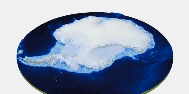
At its thickest point, the ice sheet in Antarctic is almost 3 miles (4.8 kilometers) thick.
(Image credit: British Antarctic Survey (BAS))
The new research also reveals, in unprecedented detail, the shape of the ice sheet and ice shelves that float around the fringes of the continent.
"In general, it's become clear the Antarctic Ice Sheet is thicker than we originally realized and has a larger volume of ice that is grounded on a rock bed sitting below sea level," study co-author Peter Fretwell, a mapping specialist and geographic information officer at the BAS, said in the statement.
Although thickness in itself is not a problem, the fact that much of the ice sits below sea level is concerning, because relatively warm seawater can flood into the ice sheet, Fretwell said. "This puts the ice at greater risk of melting," he added.
"What Bedmap3 is showing us is that we have got a slightly more vulnerable Antarctica than we previously thought," Fretwell added.
Antarctica quiz: Test your knowledge on Earth's frozen continent
Sascha is a U.K.-based staff writer at Live Science. She holds a bachelor’s degree in biology from the University of Southampton in England and a master’s degree in science communication from Imperial College London. Her work has appeared in The Guardian and the health website Zoe. Besides writing, she enjoys playing tennis, bread-making and browsing second-hand shops for hidden gems.
You must confirm your public display name before commenting
Please logout and then login again, you will then be prompted to enter your display name.