
 Live Science Plus


Best Earth Images of the Week - Oct. 12, 2012

Robo-maps

For the first time, scientists have made a 3-D map of sea ice in eastern Antarctica.
The map will help reveal the amount of ice in the region, which is important for understanding how climate change is affecting Antarctica.
[Full Story: Robot Sub Maps Underside of Antarctic Ice in 3-D]
Transformation of a landscape

Fall has come to Michigan's Upper Peninsula, bringing its bright colors and beautiful scenery and film student Mike Kvackay was there to take a time-lapse video of nature in all its splendor. He even got a bonus cameo from the Northern Lights.
Although Kvackay, 21, hails from Chicago, he decided to enroll in cinematography at Northern Michigan University due in part to his love of the Upper Peninsula's natural beauty. Driven by his passion for photography and nature, he taught himself how to make time-lapse videos, which involve taking thousands of pictures and stitching them together into a movie. In the beginning, it wasn't easy, Kvackay said.
[Full Story: Time-Lapse Captures Fall Color, Northern Lights]
Record highs

The sea ice circling Antarctica reached record levels late last month, extending 7.51 million square miles (19.44 million square kilometers), the most ever recorded by satellite.
The previous record was set in 2006, at 7.49 million square miles (19.39 million km), according to the National Snow and Ice Data Center (NSIDC).
[Full Story: Antarctic Sea Ice Reaches Record High Levels]

Odd find

A new species of coral has been discovered that clings to the ceilings of underwater caves in the western Pacific's Coral Triangle.
Able to tolerate low levels of light, the species lacks the symbiotic algae that most corals need to survive. The newfound species is related to deep-sea corals that survive in dark conditions below depths of 130 feet (40 meters), but so far, this species has been found no deeper than 115 feet (35 m), according to a description of the species published today (Oct. 11) in the journal ZooKeys.
[Full Story: Strange Cave-Dwelling Coral Discovered in Tropical Reefs]
Beautiful lights

When a powerful solar flare, known as a coronal mass ejection, hit Earth's magnetic field on Oct. 8, people living in North America's northern latitudes were treated to a spectacular light show.
This visible light image from the Suomi National Polar-orbiting Partnership (Suomi NPP) satellite shows the northern lights swirling across Canada's Quebec and Ontario provinces. The city lights of Montreal also shine in the bottom of the image.
[Full Story: Image: Aurora Dips South Across Canada]
Across the sky

All was calm on Russia's Kamchatka Peninsula when NASA's Terra satellite passed over at noon local time on Saturday (Oct. 6). Or so it seemed.
Underground, molten rock boiled with tectonic fury, ready to blow. And within minutes, the Shiveluch volcano erupted.
[Full Story: Satellites Watch Siberian Volcano Erupt]
Antarctic drift

As spring began to warm the Southern Hemisphere, a NASA satellite captured a snow-and-ice covered island surrounded by Antarctic icebergs.
NASA's Terra satellite spotted two icebergs, which measured more than 21 miles (35 kilometers) long, floating near South Georgia Island in the southern Atlantic Ocean, with several smaller ice chunks clustered nearby. South Georgia Island itself is only 105 miles (170 km) long from northwest to southeast.
[Full Story: Drifting Antarctic Icebergs Seen from Space]
Get the world’s most fascinating discoveries delivered straight to your inbox.
Whipped around

Winds are blowing massive clouds of Saharan dust over the Atlantic Ocean, as shown in this image captured today (Oct. 8) by NASA's Aqua satellite.
Plumes of dust extend from the Western Sahara and Mauritania to the west of the Cape Verde islands . This is the second day winds have whipped up dust storms in the region.
[Full Story: Saharan Dust Blows Over Atlantic, As Seen From Space ]
Fall Leaves at Glacier National Park
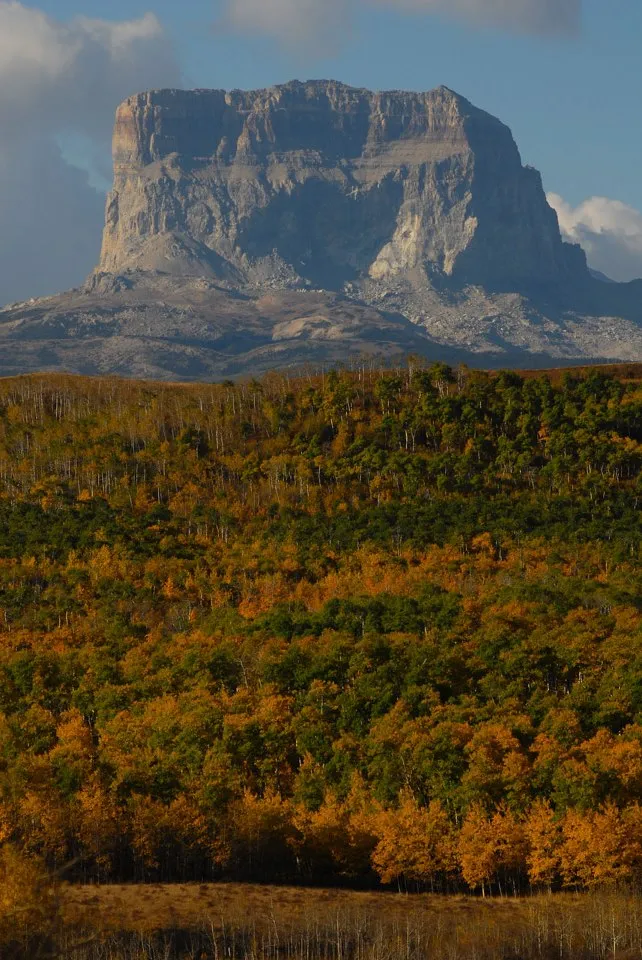
The fall foliage in Montana's Glacier National Park has arrived, in a preview of what other parts of the country can soon expect.
The National Park Service captured the above photo on Oct. 1. The fall foliage is a brilliant blend of burnt orange and dark green, with Chief Mountain looming in the background.
[Full Story: Peep the Fall Foliage at Montana's Chief Mountain]
