Our amazing planet.

Hurricane Jova Small But Strong

jova-111010-02
(Image credit: NASA)

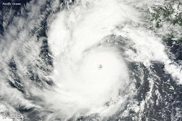
On Oct. 6, 2011, a tropical depression over the eastern Pacific Ocean strengthened into Tropical Storm Jova. On Oct. 8, Jova became a hurricane. By 11:00 a.m. Pacific Daylight Time (PDT) on Oct. 10, 2011, the U.S. National Hurricane Center (NHC) reported, Jova was a Category 3 hurricane. The storm was headed in the direction of Mexico.

Jova sports the spiral shape and distinct eye characteristic of strong storms. In the northeast, the storm's clouds graze the coast of Mexico. [Storm Targets: Where the Hurricanes Hit ]

As of 11:00 a.m. PDT on Oct. 10, Jova had maximum sustained winds of 125 mph (205 kph), and was located roughly 220 miles (255 kilometers) southwest of Manzanillo, Mexico, the NHC stated. A hurricane warning was in effect for Punta San Telmo north to Cabo Corrientes, and a tropical storm warning was in effect for Lazaro Cardenas north to Punta San Telmo.

The NHC stated that the storm could become a Category 4 hurricane, and forecast that the center of the storm would make landfall on the coast of Mexico on the afternoon or evening of Oct. 11, 2011.

Live Science Staff
For the science geek in everyone, Live Science offers a fascinating window into the natural and technological world, delivering comprehensive and compelling news and analysis on everything from dinosaur discoveries, archaeological finds and amazing animals to health, innovation and wearable technology. We aim to empower and inspire our readers with the tools needed to understand the world and appreciate its everyday awe.