 Live Science Plus


Salt Lake City Could See Bigger Earthquakes
You are now subscribed
Your newsletter sign-up was successful
Want to add more newsletters?

Delivered Daily
Daily Newsletter
Sign up for the latest discoveries, groundbreaking research and fascinating breakthroughs that impact you and the wider world direct to your inbox.

Once a week
Life's Little Mysteries
Feed your curiosity with an exclusive mystery every week, solved with science and delivered direct to your inbox before it's seen anywhere else.

Once a week
How It Works
Sign up to our free science & technology newsletter for your weekly fix of fascinating articles, quick quizzes, amazing images, and more

Delivered daily
Space.com Newsletter
Breaking space news, the latest updates on rocket launches, skywatching events and more!

Once a month
Watch This Space
Sign up to our monthly entertainment newsletter to keep up with all our coverage of the latest sci-fi and space movies, tv shows, games and books.

Once a week
Night Sky This Week
Discover this week's must-see night sky events, moon phases, and stunning astrophotos. Sign up for our skywatching newsletter and explore the universe with us!
Join the club
Get full access to premium articles, exclusive features and a growing list of member rewards.
Two faults bounding Utah's biggest city may combine to produce especially powerful earthquakes, geologists will report in Salt Lake City today (April 17) at the annual meeting of the Seismological Society of America.
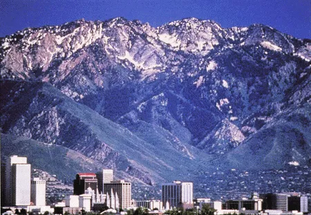
Utah's biggest earthquake fault runs east of Salt Lake City, at the base of the steep Wasatch Mountains. About 75 percent of the state's population lives near the 240-mile-long (385 kilometers) Wasatch Fault, according to the Utah Geological Survey. Its last big earthquake hit in 1600, 247 years before Mormon settlers arrived.
To the west, in urban Salt Lake City, a 4-mile-wide (6 km) zone of fault segments called the West Valley Fault Zone stretches north-northwest for 9 miles (14 km) beneath the valley.
Trenches along a portion of the West Valley fault zone, near Salt Lake City's airport, reveal that both the West Valley and Wasatch faults seem to rupture simultaneously during earthquakes, scientists will report today at the meeting.
While dating techniques can't confirm that the earthquakes were synchronous, instead of within a few days, month or years, modeling suggests they strike at the same time, said Christopher DuRoss, study co-author and a geologist at the Utah Geological Survey.
"Based on models of how the crust would behave, we expect the West Valley Fault Zone would rupture instantaneously with the Salt Lake City segment," DuRoss told OurAmazingPlanet.
Two faults, more shaking
If both fault zones ruptured during an earthquake, it would mean more shaking for Salt Lake City, which sits atop soft lake sediments, the kind that experience liquefaction during severe earthquakes. In the 2011 Christchurch, New Zealand earthquake, liquefaction destroyed the city's downtown core. In Salt Lake City, planners are also concerned about the risk of flooding from waves in the Great Salt Lake and landslides in mountain canyons during a major earthquake.
Residents of Salt Lake will get a better picture of their risk when the Utah Geological Survey and U.S. Geological Survey release updated hazard maps in 2014, which are based on today's presentation and other recent work, DuRoss said. [What's the Most Earthquake-prone State in the U.S.?]
The Wasatch Fault is divided into 10 segments, which act mostly independently, researchers think. The 25-mile-long (40 km) Salt Lake City segment is thought to be one of the most hazardous, with the probability of a large quake (magnitude 7.0) put at 16.5 percent in the next 100 years, according to the Utah Geological Survey. However, that earthquake forecast is now out-of-date, thanks to new research, and will be updated next year by the Working Group on Utah Earthquake Probabilities, DuRoss said.
Trenches find big quakes
DuRoss and study co-author Michael Hylland looked at the link between the Wasatch Fault and the West Valley Fault Zone with trenches dug near the Salt Lake City airport, where the shrinking Great Salt Lake has exposed West Valley fault traces. For the Wasatch fault, the team dug new trenches near the University of Utah.
Disturbed sediment layers indicate four big earthquakes on the West Valley fault broke ground in the past — 15,700, 13,000, 12,300 and 5,500 years ago, said Hylland, also a geologist at the Utah Geological Survey. Radiocarbon and optical luminescence dating ties the broken ground to earthquake records in trenches along the Salt Lake City section of the Wasatch Fault.

More complete sediment records exist for the Salt Lake City section of the Wasatch Fault, with nine prehistoric temblors found, Hylland said.The last big earthquake on the Salt Lake City segment was 1,400 years ago. The quakes hit every 1,300 to 1,500 years, researchers think.
"From what we can see, it looks like the frequency is about the same" on the two fault zones, Hylland told OurAmazingPlanet. "What it really comes down to is 'how active is the Salt Lake City segment?'" Hylland said. "That's the real driver of the hazard for Salt Lake Valley."
The separate faults likely merge into a single fault deep beneath the valley, Hylland said. The West Valley faults angles to the east, and the Wasatch Fault dips to the west.
Movement on both faults is up-down. They are both normal faults, sliding one block of the Earth's crust away from another block during an earthquake.
Editor's note: This story has been updated to correct the amount of time between an earthquake and the arrival of the Mormons in Utah, which was 247 years, not 147.
Email Becky Oskin or follow her @beckyoskin. Follow us @OAPlanet, Facebook & Google+. Original article on LiveScience's OurAmazingPlanet.

