A dangerous 'Omega block' is trapping scorching hot air over the US and Canada
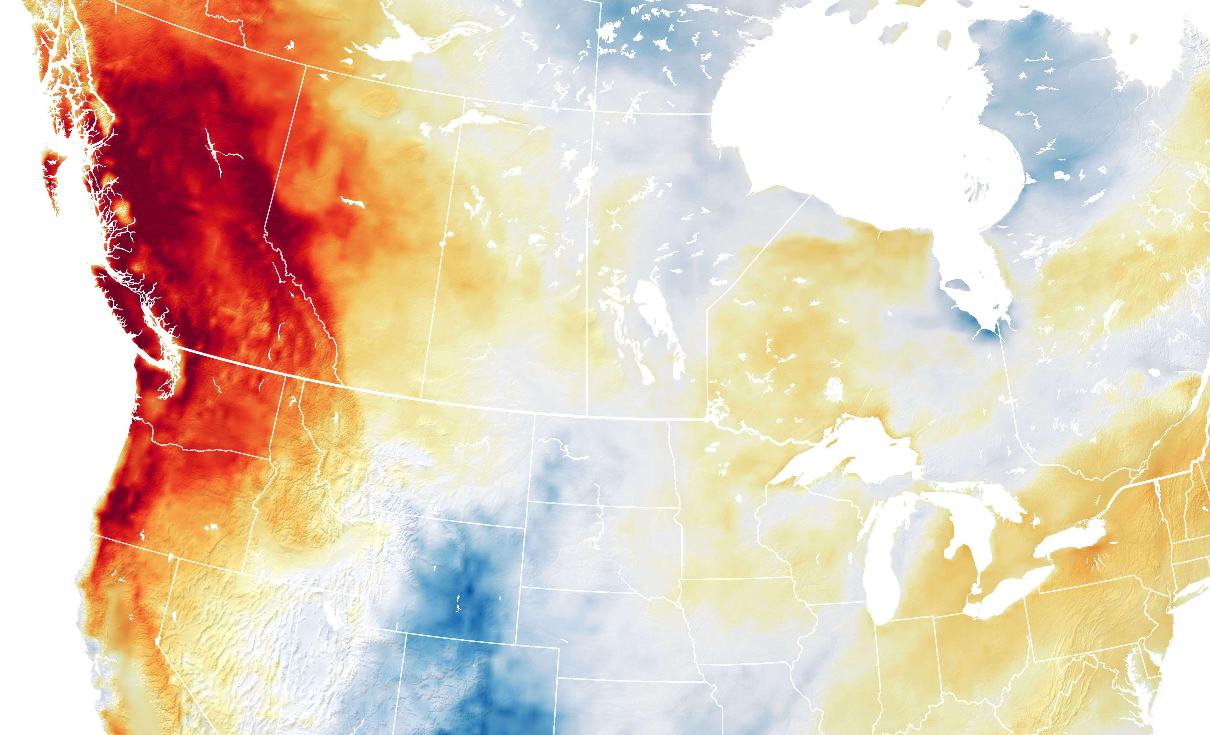
Monday was the hottest day ever for many US cities and the entire country of Canada.

Get the world’s most fascinating discoveries delivered straight to your inbox.
You are now subscribed
Your newsletter sign-up was successful
Want to add more newsletters?
Join the club
Get full access to premium articles, exclusive features and a growing list of member rewards.
The Northwestern United States and Pacific Canada are in the grips of a heat wave that the National Weather Service called "historic and dangerous" in a bulletin on Sunday (June 27). A weather anomaly called a "heat dome" is partially to blame.
In the last few days, multiple cities across Washington, Oregon, Northern California and British Columbia have seen scorching all-time heat records fall, including a reading of 108 degrees Fahrenheit (42 degrees Celsius) in Seattle on Sunday (June 27) — the city's highest recorded temperature ever — and a high of 117 F (47 C) in Salem, Oregon, on the same day. In Portland, the city's streetcar system had to cancel service for the day because the power cables were melting in the heat.
In case you're wondering why we're canceling service for the day, here's what the heat is doing to our power cables. pic.twitter.com/EqbKUgCJ3KJune 27, 2021
Meanwhile, north of the Canadian border, the town of Lytton, British Columbia, recorded a high of 116 F (47 C) on Monday — the hottest temperature ever recorded anywhere in Canada, according to NASA's Earth Observatory.
Article continues belowWhile average summer temperatures are steadily increasing every year due to human-induced global warming (2020 tied 2016 for the planet's hottest year on record, Live Science previously reported), a meteorological anomaly is also partly to blame for the Pacific Northwest heat. Conflating high- and low-pressure systems have trapped the region in a so-called heat dome, according to CBS News — essentially, "a mountain of warm air" locked in place by undulations in the jet stream (a river of strong wind weaving high through the upper atmosphere), the news site reported.
In this case, the jet stream has trapped a ridge of high pressure (that's the heat dome) over the Pacific Northwest, creating a block in the atmosphere that prevents the weather system from moving on. Instead, the hot air in the high-pressure system pushes down over the region, creating a suffocating blanket of heat. As you can see in weather maps like this one, the wind patterns swirl around the heat block in the shape of the Greek letter Omega — giving systems like these the nickname "Omega blocks," according to CBS.
Fortunately, it seems that the worst is over for now, the National Weather Service reported on Tuesday (June 29), with "the stagnant upper-level high pressure in place over the region [beginning] to shift to the east over the next couple of days." The highest temperatures will likely fall in eastern Washington, Oregon and western Idaho for the next few days, the NWS added, and eventually move over Montana by Thursday (July 1). Excessive heat advisories remain in effect for much of the region.
Originally published on Live Science.
Get the world’s most fascinating discoveries delivered straight to your inbox.

Brandon is the space / physics editor at Live Science. With more than 20 years of editorial experience, his writing has appeared in The Washington Post, Reader's Digest, CBS.com, the Richard Dawkins Foundation website and other outlets. He holds a bachelor's degree in creative writing from the University of Arizona, with minors in journalism and media arts. His interests include black holes, asteroids and comets, and the search for extraterrestrial life.
 Live Science Plus


