Colorado Wildfires Seen From Space

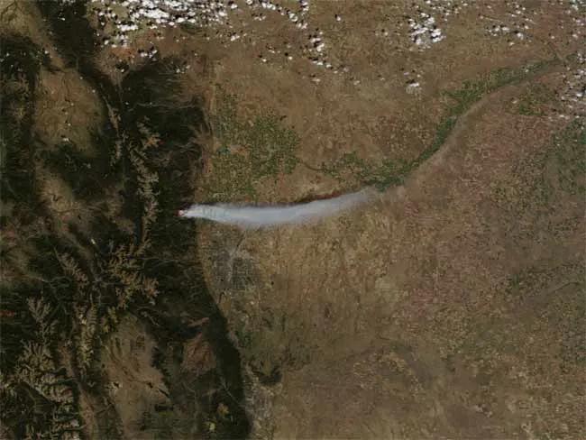
NASA's Terra satellite captured this image on Sept. 6, 2010, revealing smoke from the wildfires blazing in Boulder, Colo. The red outline corresponds with the unusually high surface temperatures associated with an active fire. (Image credit: Jeff Schmaltz, MODIS Rapid Response Team at NASA GSFC.)

A new satellite image captures the smoke from a blazing wildfire that broke out in Boulder, Colo., Monday. 

Investigators are still working to identify the cause of the so-called Fourmile Canyon Fire, according to news reports. On Sept. 6, the Geographic Area Coordination Center reported the fire had burned 3,000 acres (1,214 hectares) and was not contained on any front. The wildfire had burned 12 houses and buildings, and threatened 500 more.

The Moderate Resolution Imaging Spectroradiometer (MODIS) on NASA's Terra satellite captured the natural-color image of the fire at 12:15 p.m. local time (18:15 UTC) on Monday. The red outline corresponds with the unusually high surface temperatures associated with active wildfires. A river of thick smoke flows eastward. Over the plains northeast of Denver, the smoke plume casts a shadow to the north.

The same day that MODIS acquired this image, Boulder County issued a public health alert warning residents to limit physical activity and remain indoors if possible. On Sept. 7, smoke continued to affect air quality and limit visibility in Boulder.

Live Science Staff
For the science geek in everyone, Live Science offers a fascinating window into the natural and technological world, delivering comprehensive and compelling news and analysis on everything from dinosaur discoveries, archaeological finds and amazing animals to health, innovation and wearable technology. We aim to empower and inspire our readers with the tools needed to understand the world and appreciate its everyday awe.