


Rainbow Rivers: See Gorgeous Maps of the World's Waterways
Rivers run through

The world's rivers flow like so many rainbows in a map by Hungarian cartographer Robert Szucs, who sells his creations as digital downloads on Etsy. The maps are scientifically accurate, with the thickness of each line representing the size of each waterway. Different drainage basins are captured in different colors. [Read more about these gorgeous river maps]
Germany's colors

In this map of Germany, the Danube river basin is shown in orange. To its west, the Rhine and its tributaries are shown in blue. The Elbe and its basin are shown in purple to the northwestern side of the country.
Dry drainages
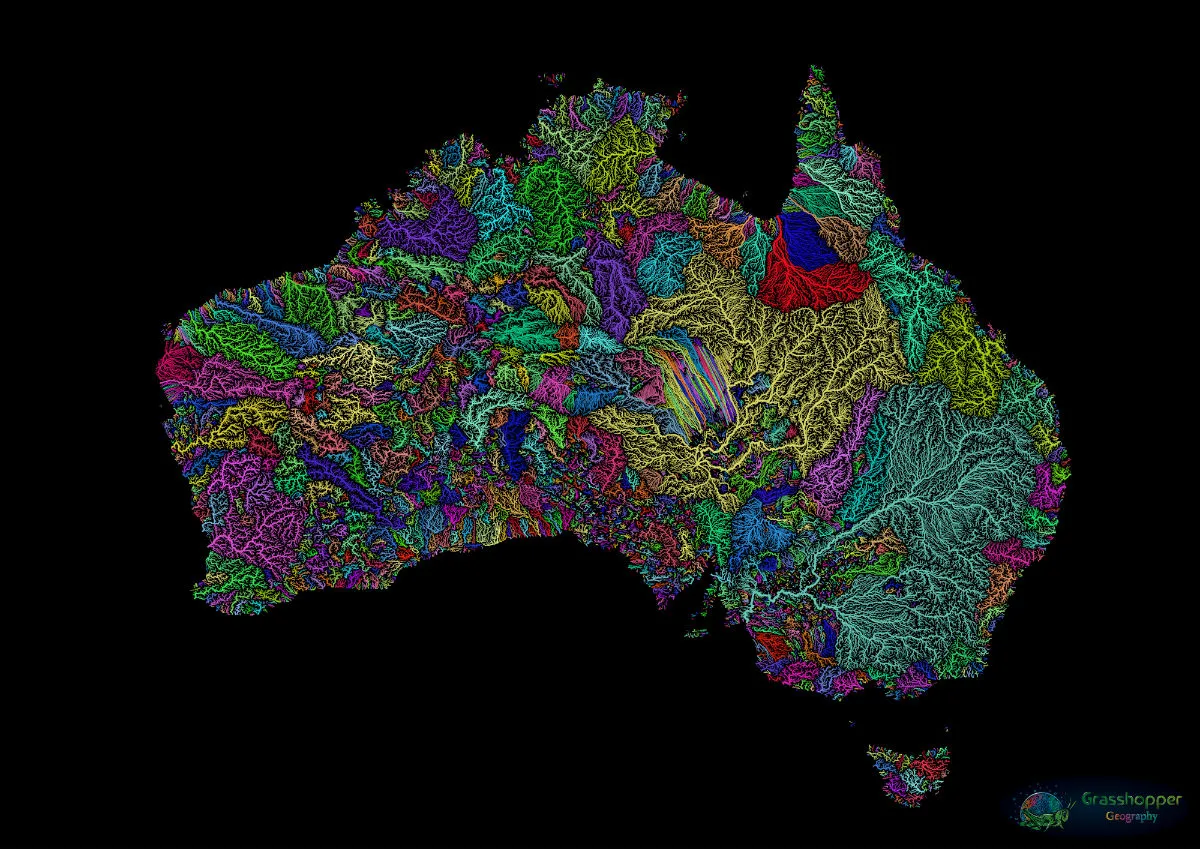
Seventy percent of Australia qualifies as arid or semi-arid, according to the Australian government. But water still flows. This map shows the drainages of the second-driest continent after Australia. In light blue to the east is the Murray-Darling basin; also notable is the Lake Eyre basin in yellow, which drains inward to Australia's lowest point, Lake Eyre; this lake sits 52 feet (16 meters) below sea level. Most of the time, Lake Eyre is a desiccated pan of salt flats. It fills with water only during years with high levels of precipitation.

Beautiful British Isles

The famous Thames appears in dark purple near the south end of England in this rainbow-hued map of the British Isles. Britain's longest river is the River Shannon in Ireland, its length and tributaries shown in red.
Forested Europe

Cartographer Robert Szucs also creates forest-cover maps, including this otherworldly view of Europe. Brighter, more concentrated green indicates greater forest cover, while darker areas host fewer trees. The Scandes, or the Scandinavian Mountain Range, stands out as a treeless chain running through Norway, Finland and Sweden, where the land is too high, rocky and icy to support much vegetation.
Waterways of Europe

The major rivers of Europe appear in a kaleidoscope of color in cartographer Robert Szucs' map of river basins. The Danube drainage is shown in dark red; the Rhine and the Rhone flow in yellow and green. In yellow is the Volga basin, feeding Europe's longest river.
Africa's flow

Africa's river basins stand out in sumptuous color. The large dark purple basin in the center of the continent is the Congo River basin, the second-largest river basin in the world after the Amazon River basin. The longest river in Africa, the Nile, and its basin are showcased in bright red. To the west, in light purple, is the Niger River basin.
Get the world’s most fascinating discoveries delivered straight to your inbox.
A rumpled boot

A more traditional map of Italy shows the country's elevation from lowest (green) to highest (red).
Rivers of North America

The Mighty Mississippi dominates the North American landscape in dark blue. According to the Environmental Protection Agency, the Mississippi/Atchafalaya River basin drains an area more than 1.2 million square miles in size, or 15 percent of all of North America. Another major drainage, the Yukon River and its basin, can be seen in Alaska and British Columbia in bright pink.
Russia's rivers

Russia's three major Arctic-draining river basins are on display in this colorful map from Grasshopper Geography. The Lena, the easternmost, is in light blue. In teal, to its west, is the Yenisei, the largest river system that feeds into the Arctic. To the west of the Yenisei is the Ob, in yellow.
Deep in the heart of Texas

The Lone Star State gets the rainbow treatment in this map showing Texas' drainages. The Rio Grande defines the southern border in light blue. The Colorado appears in pink, bordered by the Brazos in dark blue. On the northeastern border and in the panhandle is the Red River and its basin, shown in bright green.

Stephanie Pappas is a contributing writer for Live Science, covering topics ranging from geoscience to archaeology to the human brain and behavior. She was previously a senior writer for Live Science but is now a freelancer based in Denver, Colorado, and regularly contributes to Scientific American and The Monitor, the monthly magazine of the American Psychological Association. Stephanie received a bachelor's degree in psychology from the University of South Carolina and a graduate certificate in science communication from the University of California, Santa Cruz.