What's Causing Louisiana's Historic Flooding?

Get the world’s most fascinating discoveries delivered straight to your inbox.
You are now subscribed
Your newsletter sign-up was successful
Want to add more newsletters?
Join the club
Get full access to premium articles, exclusive features and a growing list of member rewards.
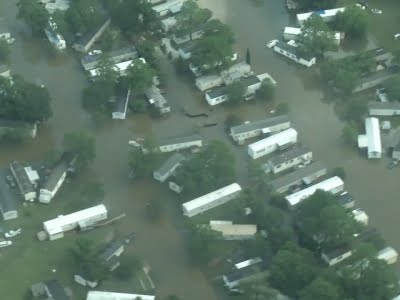
Tremendous downpours have inundated parts of Louisiana over the last few days, resulting in disastrous flooding and forcing thousands of people from their homes. But what's causing this historic flooding in areas that rarely receive such significant rainfall days?
An "inland sheared tropical depression" is how the National Oceanic and Atmospheric Administration's National Weather Service (NWS) described the heavy rain event on Friday morning (Aug. 12). The NWS also noted that the moisture content in the atmosphere was close to an all-time record for the area, even higher than observations during some tropical cyclones.
"Like a tropical depression, the low had a warm core, and the counterclockwise flow of air around the storm brought huge amounts of tropical moisture from the near-record-warm waters of the Gulf of Mexico and northwest Atlantic northwards over land," meteorologists Jeff Masters and Bob Henson wrote on their blog, Weather Underground. "The amount of moisture in the atmosphere over the Gulf Coast region over the past week has been nothing short of phenomenal," they wrote. [Mightiest Floods of the Mississippi River]
Article continues belowA combination of tropical moisture and low pressure fueled the immense rainfall in Louisiana and southwest Mississippi, the meteorologists said. When so much moisture is in the atmosphere, storms can produce rainfall of several inches in a single hour, resulting in astronomical totals over time, the meteorologists said.
In his analysis for Pacific Standard, meteorologist Eric Holthaus noted the rarity of such a significant amount of rainfall.
"By midmorning on Friday, more than a foot [more than 30 centimeters] of rain had fallen near Kentwood, Louisiana, in just a 12-hour stretch — a downpour with an estimated likelihood of just once every 500 years, and roughly three months' worth of rainfall during a typical hurricane season," Holthaus wrote. Such an event is known as a 500-year rainfall.
While, historically, such rain events are incredibly rare, this is at least the eighth 500-year (or rarer) rainfall event in America since just last May, Holthaus said.
Get the world’s most fascinating discoveries delivered straight to your inbox.
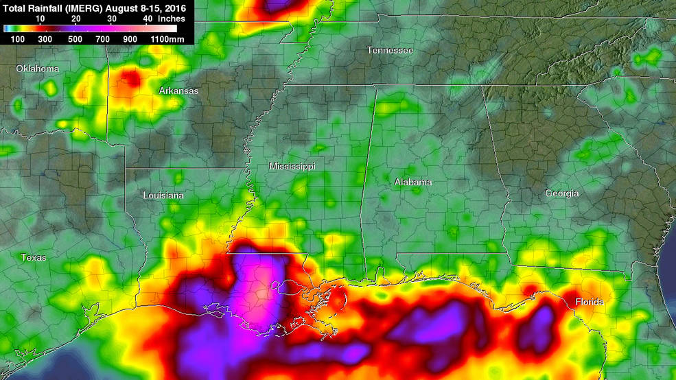
With rainfall totals in the double digits — NASA's Global Precipitation Measurement mission estimated more than 20 inches (508 millimeters) of rainfall in large areas of southeastern Louisiana and southern Mississippi — rivers were rapidly rising, causing serious flooding.
At least six rivers in Louisiana have hit record levels since the rainfall event began on Friday, reported the Weather Channel. The most extreme flooding has occurred along the Amite River, which exceeded its previous height record in Magnolia, Louisiana, by more than 6 feet (1.8 meters).
At least eight people have died in the severe flooding, Louisiana Gov. John Bel Edwards said during a press conference Tuesday (Aug. 16), and 40,000 homes have been affected. An estimated 30,000 people have been rescued from flooded homes and vehicles.
"This is certainly a critical time for all of us in south Louisiana," Edwards said. "This is a historic flooding event, and when you have a storm that is unnamed … a lot of times people underestimate the impact that it would have."
Though the amount of rain is expected to ease in the flood-ravaged areas, rainfall is forecast to continue through the week, according to the NWS. The threat of flooding looms through the weekend as well, with the NWS predicting the potential for significant flooding lasting until Sunday (Aug. 21).
Original article on Live Science.

 Live Science Plus


