


Photos: World War II-Era Aircraft Carrier Discovered
Scientists with the National Oceanic and Atmospheric Adminstration, in partnership with Boeing, have pinpointed the aircraft carrier USS Independence, located nearly a half mile beneath the Pacific Ocean off the California coast. Sonar images revealed the condition of the purposely sunk ship. [Read full story on the USS Independence shipwreck ]
USS Independence
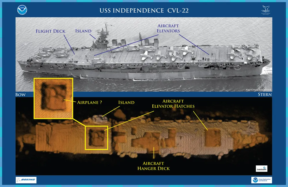
Features on an historic photo of USS Independence CVL 22 are captured in a three-dimensional (3D) low-resolution sonar image of the shipwreck in Monterey Bay National Marine Sanctuary. The Coda Octopus Echoscope 3D sonar, integrated on the Boeing Autonomous Underwater Vehicle (AUV) Echo Ranger, imaged the shipwreck during the first maritime archaeological survey. The sonar image with oranges color tones (lower) shows an outline of a possible airplane in the forward aircraft elevator hatch opening. (Credit: NOAA, Boeing, and Coda Octopus.)
Echo Ranger

During the 2015 mission to survey the ex-USS Independence CVL 22, the Office of National Marine Sanctuaries' research vessel Fulmarserved as the escort boat for Boeing’s Autonomous Underwater Vehicle (AUV) Echo Ranger. The 67-foot aluminum catamaran research vessel’s crew is preparing to tow Echo Ranger to sea. (Credit: Robert V. Schwemmer, NOAA.)
Power source

Boeing's project engineer, Ross Peterson, oversees the installation of the lithium polymer battery into Boeing's Autonomous Underwater Vehicle (AUV) Echo Ranger at Half Moon Bay. The battery is specifically designed for the AUV, providing the power needed for the 60 mile roundtrip mission in the Monterey Bay National Marine Sanctuary. (Credit: Robert V. Schwemmer, NOAA.)
Get the world’s most fascinating discoveries delivered straight to your inbox.
Echo Ranger

Illustration of Echo Ranger. (Credit: Boeing.)
Attention to Colors

Muster on the flight deck of USS Independence (CVL 22), 1943. “Attention to Colors,” as the American flag is being hoisted aloft. (Credit: U.S. Navy, National Archives.)
Locating history

The shipwreck site of the former aircraft carrier, Independence, is located in the northern region of Monterey Bay National Marine Sanctuary. Half Moon Bay, California was the port of operations for the Independence survey mission. The first multibeam sonar survey of the Independence site was conducted by the NOAA ship Okeanos Explorer in 2009. (Credit: NOAA's Office of Ocean Exploration and Research and NOAA's Office of National Marine Sanctuaries.)
Change in status

Aerial view of USS Independence (CVL 22) underway July 15, 1943 in San Francisco Bay, California. Before departing San Francisco, USS Independence’s hull classification changed from CV 22 “aircraft carrier” to CVL 22, “light aircraft carrier.” (Credit: U.S. Navy, National Archives, 80-74436.)
Testing damage

Aerial view of ex-USS Independenceat anchor in San Francisco Bay, California, January 1951. There is visible damage from the atomic bomb tests at Bikini Atoll. (Credit: San Francisco Maritime National Historical Park, P82-019a.3090pl_SAFR 19106.)
The ship today

The ROV took several sonar images of each section of the ship, giving a high-resolution picture. The sonar painted a clear picture of the ship, with the colors showing its topography. (Credit: NOAA/Boeing.)
Follow Live Science @livescience, Facebook & Google+.
