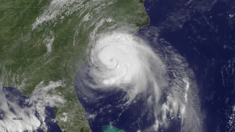
The GOES East satellite caught this picture of Hurricane Arthur on the morning of July 3, 2014, a day before it was expected to make a direct hit on North Carolina.
North Carolina’s coast is in the bulls-eye of Hurricane Arthur, the first hurricane of the 2014 Atlantic season, which strengthened from a tropical storm overnight Wednesday. Arthur could swamp North Carolina’s coastline with several feet of storm surge, prompting evacuations in the Outer Banks. It has also forced the rescheduling of Fourth of July celebrations along the East Coast ahead of its expected trek northward.
As of 8 a.m. Thursday, satellite imagery and data collected by hurricane hunter aircraft showed that Arthur’s winds had strengthened to 80 mph, easily above the 74 mph cutoff that separates tropical storms from hurricanes. By 11 a.m., Arthur’s winds had risen to a sustained 90 mph, with higher gusts, making it a strong Category 1 hurricane. The storm could ramp up further over the next 24 hours, as it moves over warm waters and remains in a favorable atmospheric environment, according to the National Hurricane Center, which expects Arthur to hit as a Category 2 storm.
Arthur’s expected path puts it on a collision course with the Outer Banks of North Carolina, prompting local officials to issue a mandatory evacuation order for Hatteras Island and voluntary orders for other areas. There is some uncertainty in the exact track the storm will take, and it could shift to a more direct hit on North Carolina or veer further out to sea. If it moves as expected, it will make landfall in North Carolina around 2 a.m. EDT on Friday. The outer rainbands of the hurricane were already brushing the coast on Thursday morning.
The hurricane has offered NHC officials with their first chance to roll out new experimental storm surge flooding maps. The maps are aimed at giving coastal residents a clearer picture of how surging ocean waters that a hurricane pushes in front of it might affect their area. Storm surge, combined with the tides, could cause waters to reach 3 to 5 feet above ground in the area under a hurricane warning, which stretches from Surf City, N.C., to the North Carolina-Virginia border. Pamlico and eastern Albemarle Sounds, though included in the warning, could see slightly lower surge of 2 to 4 feet, the NHC said. Southern North Carolina and northeastern South Carolina could see 1 to 3 feet, and extreme southeastern Virginia, 1 to 2 feet.
Surge flooding is highest on the side of a storm where winds are pushing in toward land, propelling ocean waters in front of them. Storm surge has become an increasing threat to coastal communities as populations there expand and as Earth’s warming causes sea levels to rise. Surge is typically the most destructive and deadly part of a hurricane.
The anticipated arrival of Arthur has prompted the rescheduling of Fourth of July celebrations from North Carolina to Massachusetts. The Raleigh News & Observer reported that festivities along the North Carolina coast had been postponed to other days this weekend, and Boston moved their famous Boston Pops Concert to Thursday evening, as the storm was expected to brush the Cape overnight Friday.
Sign up for the Live Science daily newsletter now
Get the world’s most fascinating discoveries delivered straight to your inbox.
A zoomed-in view of potential storm surge flooding in the Wilmington, N.C., area from Tropical Storm Arthur.
(Image credit: NHC/NOAA)
Arthur is the first storm in the Atlantic Ocean basin to receive a name so far in the 2014 season, which began on June 1 and is expected to be somewhat below-normal in activity, thanks to a burgeoning El Niño. The cyclic climate phenomenon, characterized by warmer-than-normal ocean waters in the eastern tropical Pacific, influences atmospheric patterns around the globe and tends to create conditions that hamper the development of tropical storms and hurricanes in the Atlantic.
While most hurricane activity in the Atlantic typically occurs in August and September, when broader swaths of the Atlantic have warm enough temperatures to support storm development, Arthur’s July formation is not unusual. Typically the first named storm of a season occurs by July 9, and the area where where Arthur spun up is one of the likely areas to see storms form at this time in the year.
Arthur’s path toward North Carolina is also not unusual, as the state has seen the fourth most direct hits from hurricanes of any state (behind Florida, Texas, and Louisiana, in that order).
While the U.S. has been hit by several Category 1 and 2 hurricanes in the past few years, the last major hurricane (defined as a Category 3 or higher) to hit the country was Wilma in October 2005. While Sandy caused considerable damage and was a large storm, it was not a hurricane when it made landfall.
Andrea Thompson is an associate editor at Scientific American, where she covers sustainability, energy and the environment. Prior to that, she was a senior writer covering climate science at Climate Central and a reporter and editor at Live Science, where she primarily covered Earth science and the environment. She holds a graduate degree in science health and environmental reporting from New York University, as well as a bachelor of science and and masters of science in atmospheric chemistry from the Georgia Institute of Technology.