The Carta Marina in Images

Carta marina

Carta marina

(Image credit: Courtesy of the Library of Congress and the Jay I Kislak Foundation.)

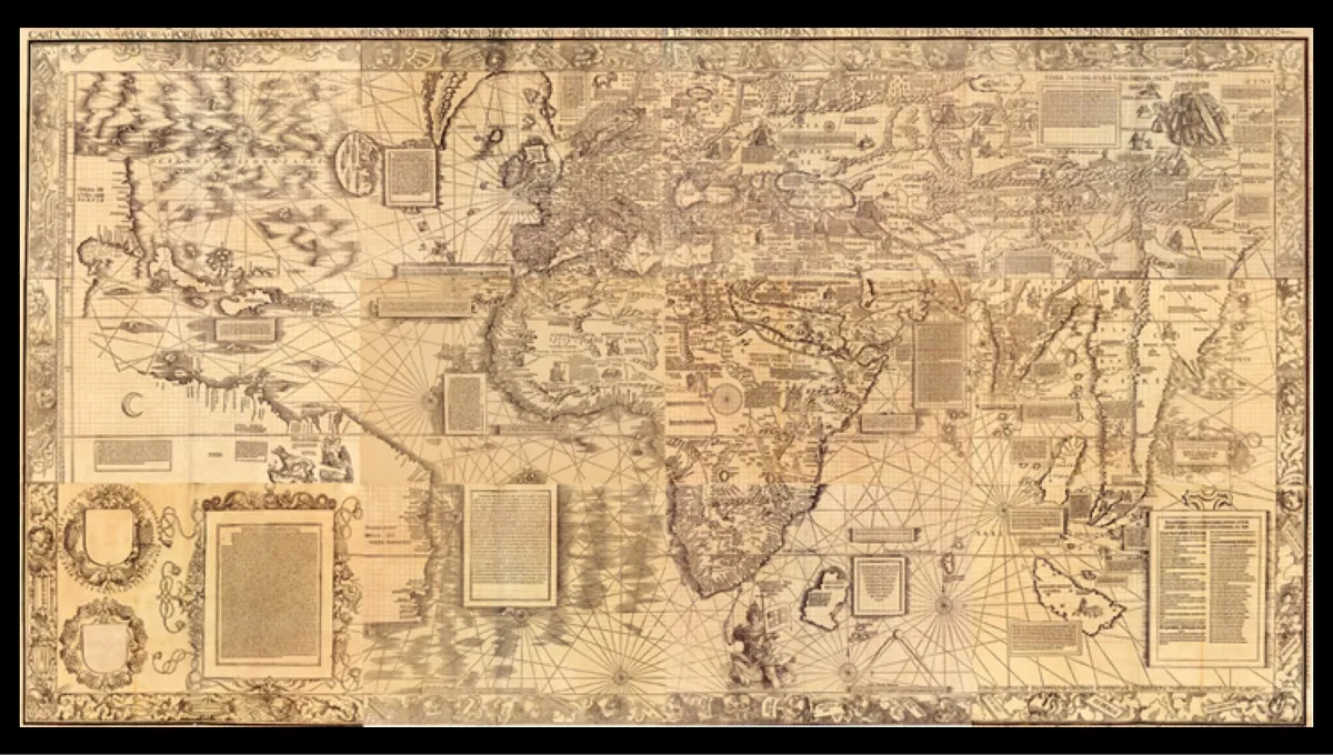
Renaissance cartographer Martin Waldseemüller's 1516 "Carta marina" was the second of two famous maps he made.

1507 Waldseemüller World Map

1507 Waldseemüller World Map

(Image credit: the LC and the Jay I Kislak Foundation.)

Waldseemüller is best known for his 1507 world map, the first to call the New World "America."

Ptolemaic World Map (c.1460)

Ptolemaic World Map (c.1460)

(Image credit: Courtesy of the Library of Congress and the Jay I Kislak Foundation.)

Waldseemüller began his career by basing his maps on those of the Alexandrine geographer Claudius Ptolemy from the second century AD.

World Map by Henricus Martellus (c. 1491)

World Map by Henricus Martellus (c. 1491)

(Image credit: Courtesy of the Library of Congress and the Jay I Kislak Foundation.)

Waldseemüller's 1507 world map was closely based on a Ptolemaic map by Henricus Martellus.

1513 Ptolemaic world map

1513 Ptolemaic world map

(Image credit: Courtesy of the Library of Congress and the Jay I Kislak Foundation.)

After his 1507 world map, Waldseemüller made maps that appeared in the 1513 edition of "Ptolemy's Geography."

Modern world map in 1513 Ptolemy

Modern world map in 1513 Ptolemy

(Image credit: Courtesy of the Library of Congress and the Jay I Kislak Foundation.)

Waldseemüller included some modern maps based on nautical charts in the his 1513 atlas too.

Carta marina texts

Carta marina texts

(Image credit: Courtesy of the Library of Congress and the Jay I Kislak Foundation.)

Waldseemüller's map is crowded with descriptive texts and illustrations of royal rulers.

A cartographer at work (Pfinzing's Methodus geometrica, 1598)

A cartographer at work (Pfinzing's Methodus geometrica, 1598)

(Image credit: Courtesy of the Library of Congress and the Jay I Kislak Foundation.)

While at work on the Carta marina, Waldseemüller may have looked something like this.

Nicolo de Caverio nautical chart (c. 1503)

Nicolo de Caverio nautical chart (c. 1503)

(Image credit: Courtesy of the Library of Congress and the Jay I Kislak Foundation.)

Waldseemüller based the Carta marina's coastlines on a nautical chart made by Nicolo de Caverio of Genoa in about 1503.

Pierre d'Ailly's Imago mundi

Pierre d'Ailly's Imago mundi

(Image credit: Courtesy of the Library of Congress and the Jay I Kislak Foundation.)

One of the sources Waldseemüller lists for his Carta marina is Pierre d’Ailly, a French cardinal, theologian and cosmographer who wrote a cosmographical book titled the Imago mundi or Image of the World in 1410.

Map by Johannes Ruysch (1507)

Map by Johannes Ruysch (1507)

(Image credit: Courtesy of the Library of Congress and the Jay I Kislak Foundation.)

The Carta marina contains a legend describing inhabitants of the New World, likely taken from a world map by Johannes Ruysch.

Tanya Lewis
Staff Writer
Tanya was a staff writer for Live Science from 2013 to 2015, covering a wide array of topics, ranging from neuroscience to robotics to strange/cute animals. She received a graduate certificate in science communication from the University of California, Santa Cruz, and a bachelor of science in biomedical engineering from Brown University. She has previously written for Science News, Wired, The Santa Cruz Sentinel, the radio show Big Picture Science and other places. Tanya has lived on a tropical island, witnessed volcanic eruptions and flown in zero gravity (without losing her lunch!). To find out what her latest project is, you can visit her website.