In an era when much of the Earth has been photographed in minute detail by satellite, Michael Bevis' B4 project could seem quaint: Bevis used a humble Cessna to survey some 621 miles of the San Andreas Fault.
But the result is the most detailed visual survey of the California fault ever made.
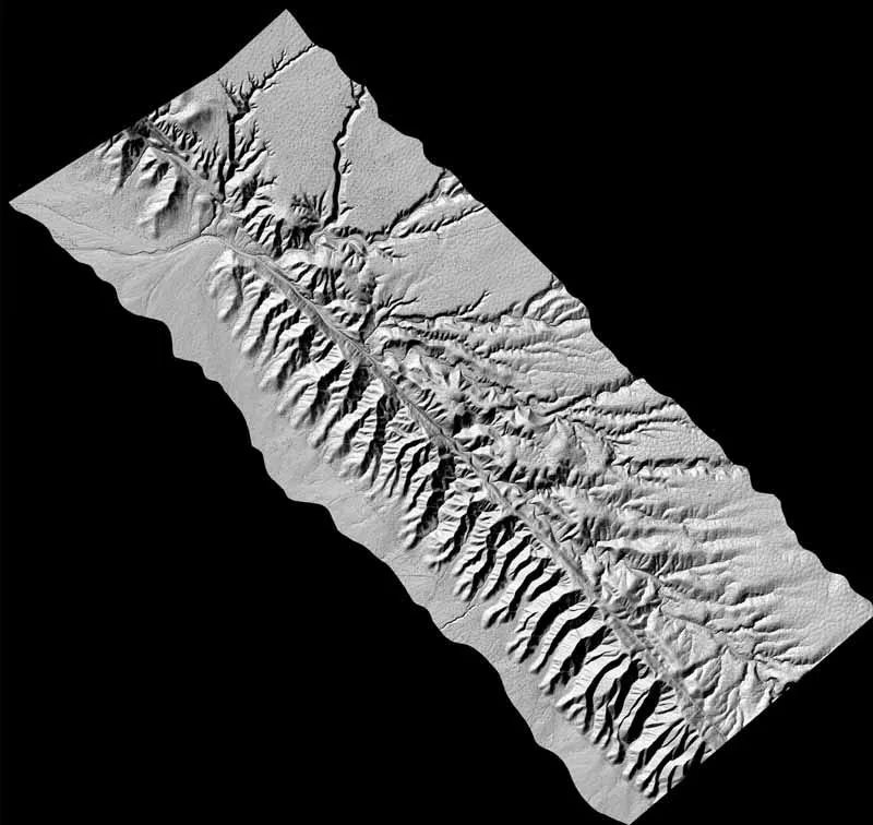
Details, some as small as two inches, are visible in the new images. Fault lines that hadn't been seen before are now evident, along with the area's trees and some cows.
Latest Videos From
And when the next great earthquake reconfigures the huge crack yet again, Bevis and his colleagues will be ready to hop back in the Cessna and to gather an unprecedented set of comparative images.
The goal: To learn more about how an earthquake actually starts and pin down what happens in and near a fault line. The San Andreas was responsible for the 1906 San Francisco quake and has produced great earthquakes in Southern California, too. Geologists say another devastating magnitude-8 or higher earthquake is inevitable.
"By having this high resolution image of before and after a quake, we should be able to resolve some of these debates," the Ohio State University researcher says.
Bevis is scheduled to present images from the B4 (short for "before") survey today at a meeting of the American Geophysical Union.
The images are not conventional pictures. They were created using the Global Positioning System (GPS) and a radar-like setup called LIDAR (light detection and ranging). LIDAR bounces a light beam off the surface and measures the time it takes to return.
The project required precision flying, using the GPS, so that the LIDAR instrument could map subtle variations in terrain.
"We had to fly low and closely manage the orientation of the aircraft at all times so we knew exactly where the laser on the LIDAR instrument was pointing," Bevis explained. "To do this kind of survey the traditional way would take years—just to process the photographs."
Bevis and his colleagues wrapped up the survey in August and have yet to fully analyze the data. Preliminary results are expected in a month. Meanwhile, images are being posted to a web site as they are processed.
"People are going to find all kinds of faults and other features that they never knew about before," Bevis said. "There are some spots where, if you were actually standing on the ground, and you weren't a geologist who knows the area really well, you probably couldn't even see it. But in these images you can."
Bevis even spotted the SUV of one of his colleagues in an image. Some such features can be difficult to make out. But the cows were fairly easy to identify.
"When we looked back later, some of them had moved," Bevis said.


 Live Science Plus


