The Natural Colors of North America
Get the world’s most fascinating discoveries delivered straight to your inbox.
You are now subscribed
Your newsletter sign-up was successful
Want to add more newsletters?
Delivered Daily
Daily Newsletter
Sign up for the latest discoveries, groundbreaking research and fascinating breakthroughs that impact you and the wider world direct to your inbox.
Once a week
Life's Little Mysteries
Feed your curiosity with an exclusive mystery every week, solved with science and delivered direct to your inbox before it's seen anywhere else.
Once a week
How It Works
Sign up to our free science & technology newsletter for your weekly fix of fascinating articles, quick quizzes, amazing images, and more
Delivered daily
Space.com Newsletter
Breaking space news, the latest updates on rocket launches, skywatching events and more!
Once a month
Watch This Space
Sign up to our monthly entertainment newsletter to keep up with all our coverage of the latest sci-fi and space movies, tv shows, games and books.
Once a week
Night Sky This Week
Discover this week's must-see night sky events, moon phases, and stunning astrophotos. Sign up for our skywatching newsletter and explore the universe with us!
Join the club
Get full access to premium articles, exclusive features and a growing list of member rewards.
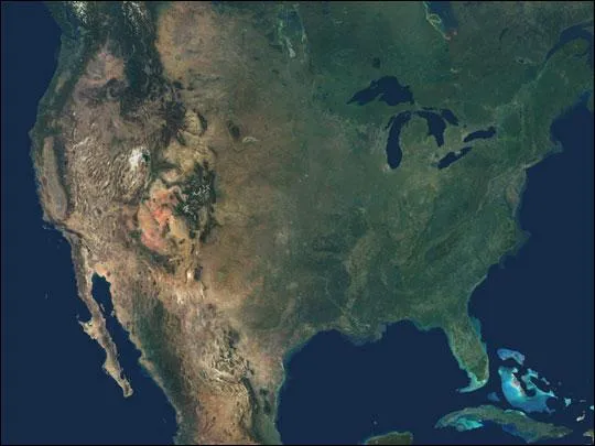
This natural-color image combines cloud-free data from over 500 Multi-angle Imaging SpectroRadiometer (MISR) orbits with shaded relief Digital Terrain Elevation models from the Shuttle Radar Topography Mission (SRTM) and other sources. An astonishing diversity of geological features, ecological systems and human landscapes across North America is indicated within the image.
In addition to the contiguous United States, the full-size scene spans from British Columbia in the northwest to Newfoundland in the northeast, and extends eastward to the lonely Bermuda Islands and southward to the Bahamas, Cuba and Mexico. Draped in green, the eastern and central United States and Canada contrast with the vibrant geology that is laid bare across the arid portions of the southwestern United States and central Mexico. Along Mexico's east coast, the lush vegetation to the east of the Sierra Madre mountain range indicates the orographic rainfall gradient along this subtropical-tropical coast. In the high Rocky Mountains and in British Columbia's Coast Range, many peaks remain snow-covered year round.
The Multi-angle Imaging SpectroRadiometer observes the daylit Earth continuously and every 9 days views the entire globe between 82
Get the world’s most fascinating discoveries delivered straight to your inbox.

