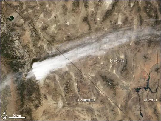
In this satellite image, what might be mistaken for smoke from a forest fire is actually a wide plume of ice crystals in other words, a cirrus cloud, according to a NASA statement.
This particular cloud seems to defy the conventional description of cirrus as thin, wispy, often curly clouds. Cirrus generally form at high altitudes (near 20,000 feet, or about 6 kilometers), where temperatures are cold and water vapor is usually scarcer than at lower altitudes.
The plume captured in this image from the Moderate Resolution Imaging Spectroradiometer (MODIS) on NASA's Terra satellite on Oct. 30, 2002, was instigated by air flow over a handful of high peaks in southern California's Sierra Nevada Mountains.
Latest Videos From
For the air flowing in from the west, the mountains act like a ramp into higher and colder layers of the atmosphere, where water vapor solidifies into tiny ice crystals. The number and size of the ice particles depends on the air temperature, relative humidity, and the vertical speed of the rising air.
The length of this plume is rather unusual. Although topography can force air to rise quickly, gravity will also work quickly to draw the temporarily buoyant air back toward the Earth's surface (if the atmosphere is otherwise stable). As the air descends "downstream" of the mountains, it is generally warming and expanding, processes that favor cloud evaporation, not formation.
When scientists analyzed atmospheric conditions and weather models of the area at the time of the plume, they discovered that several factors contributed to the thickness and extent of the plume. A relatively thick layer of moist but cold air at high altitudes and strong terrain-driven updrafts created high concentrations of very small particles.
The presence of the ice crystals themselves reduced the air's relative humidity , which prevented the crystals from growing much larger. Smaller crystals have slower terminal velocities (the speed at which acceleration due to gravity and deceleration due to air resistance, or drag, are equal), and they were able to stay aloft for hundreds of kilometers downstream of the mountains.