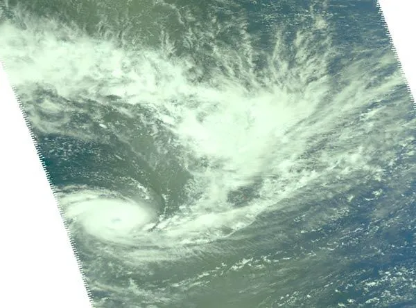
Cyclone Wilma is churning across the Southwestern Pacific Ocean and yesterday (Jan. 25), her eye was clearly visible from space.
On Jan. 25 at 00:59 UTC (8:59 p.m. EST on Jan. 24), the Atmospheric Infrared Sounder (AIRS) instrument captured data that was used to create infrared and visible images at NASA's Jet Propulsion Laboratory in Pasadena, Calif. The images showed Cyclone Wilma had strengthened overnight and now has a visible eye.
The imagery showed strong, very cold thunderstorm cloud tops around Wilma's center of circulation. The cloud tops were as cold as or colder than minus 63 degrees Fahrenheit (minus 52 degrees Celsius) indicating strong convection (rapidly rising air that creates the thunderstorms that power a tropical cyclone).
Latest Videos From
The images also showed what appears to be a large "tail" from Wilma's center, stretching several hundred miles to the northeast of the storm's center.
Cyclones are the same phenomenon as hurricanes, typhoons and tropical storms. The different names are used depending on the ocean basin over which the storm occurs.
On Jan. 25 at 0900 UTC (4 a.m. EST), Tropical Cyclone Wilma had maximum sustained winds near 97 mph (157 kph). It was located about 360 nautical miles southeast of Nadi, Fiji was moving southwestward near 27 mph (44 kph).
A Tropical Cyclone Warning is in force for areas of Tonga and for areas of Fiji. On its projected path, Tropical Cyclone Wilma is expected to pass about 124 miles (200 km) south-southeast of Ono-i-lau by midnight local time tonight.
Republic of the Fiji Islands is an island nation in Melanesia in the South Pacific Ocean about 1,243 miles (2,000 km) northeast of New Zealand's North Island. Vanuatu is located to the west, and New Caledonia is located to the southwest. Tonga is located east of Fiji. Tonga is an archipelago comprised of 176 islands scattered over 270,000 square miles (700,000 square kilometers).
Wilma is forecast to continue moving southwest parallel to Fiji and New Caledonia as it makes its way toward New Zealand. On January 28 it is forecast to change course and head southeast bringing rains and gusty winds to northern New Zealand.

 Live Science Plus