Bahamas from Above: Brilliant Blues and Sandy Shores
Get the world’s most fascinating discoveries delivered straight to your inbox.
You are now subscribed
Your newsletter sign-up was successful
Want to add more newsletters?
Delivered Daily
Daily Newsletter
Sign up for the latest discoveries, groundbreaking research and fascinating breakthroughs that impact you and the wider world direct to your inbox.
Once a week
Life's Little Mysteries
Feed your curiosity with an exclusive mystery every week, solved with science and delivered direct to your inbox before it's seen anywhere else.
Once a week
How It Works
Sign up to our free science & technology newsletter for your weekly fix of fascinating articles, quick quizzes, amazing images, and more
Delivered daily
Space.com Newsletter
Breaking space news, the latest updates on rocket launches, skywatching events and more!
Once a month
Watch This Space
Sign up to our monthly entertainment newsletter to keep up with all our coverage of the latest sci-fi and space movies, tv shows, games and books.
Once a week
Night Sky This Week
Discover this week's must-see night sky events, moon phases, and stunning astrophotos. Sign up for our skywatching newsletter and explore the universe with us!
Join the club
Get full access to premium articles, exclusive features and a growing list of member rewards.
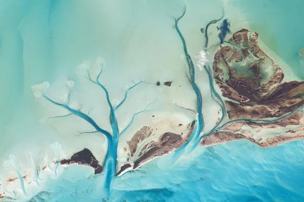
The islands of the Bahamas are situated on large depositional platforms the Great and Little Bahama Banks composed mainly of carbonate sediments ringed by reefs. The islands are the only parts of the platform currently exposed above sea level.
The sediments were formed mostly from the skeletal remains of organisms settling to the sea floor; over geologic time, these sediments consolidated to form carbonate sedimentary rocks such as limestone.
This astronaut photograph provides a view of tidal flats and channels near Sandy Cay, on the western side of Long Island and along the eastern margin of the Great Bahama Bank. The continuously exposed parts of the island are brown, a result of soil formation and vegetation growth.
To the north of Sandy Cay, an off-white tidal flat composed of carbonate sediments is visible; light blue-green regions indicate shallow water on the tidal flat. The tidal flow of seawater is concentrated through gaps in the land surface, leading to the formation of relatively deep channels that cut into the sediments. The channels and areas to the south of the island have a vivid blue color that indicates deeper water.
- Natural Art: The Ocean Blooms
- The World's Biggest Oceans and Seas
- Observing Earth: Amazing Views from Above
Get the world’s most fascinating discoveries delivered straight to your inbox.

