The tallest volcanic peak in Peru is aptly named Nevado (the Spanish word for "snowy") Coropuna (the Quechua term for roughly "shrine on the plateau"), as the volcano is tipped with ice deposits and has long been considered a sacred mountain by locals.
Nevado Coropuna is not a typical stratovolcano. The mountain comprises multiple summit cones, six in total, which makes Coropuna one of the largest volcanoes in the Americas. The entire structure covers an area of 93 square miles (240 square kilometers).
Nevado Coropuna is located within the Ampato mountain range in southeast-central Peru, around 60 miles (96 km) northwest of Arequipa, a city in southern Peru. The mountain reaches to about 20,900 feet (6,377 m) above sea level, though there are varying estimates given for its height. Six of its peaks reach over 6,000 meters in height.
Latest Videos From
Nevado Coropuna was once believed to be the highest mountain in the Americas, according to SummitPost.org. A Yale archaeology team discovered that the mountain was not the highest when they scaled it and measured it in 1911. The highest mountain in the Americas, is Aconcagua in the Andes Mountains at a height of 22,841 feet (6,962 m). The highest volcano in the Americas, and the world, is Nevado Ojos del Salado, or "water source of the salty river," which stand 22,608 feet (6,893 meters) tall in the Chilean Andes.
The volcano is currently dormant, but lava flows located along the northern, southern and western flanks are thought to have been placed during the early Holocene Epoch the current geologic time period, which began approximately 12,000 years ago.
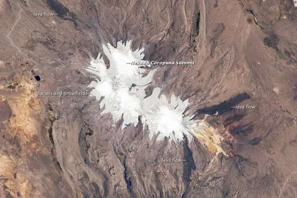
Due to its height, Coropuna also hosts several summit glaciers and ice fields. These can be located in the above image (taken by an astronaut aboard the International Space Station) because the ice contrasts sharply with the dark rock outcrops and surface deposits at lower elevations.
Careful mapping and surface exposure age-dating of these deposits and landforms provides information regarding the timing of ice advances and retreats in the tropics near the end of the Pleistocene Epoch (extending from about 2.5 million to 12,000 years ago). This information can be compared with other paleoclimate records to obtain a better understanding of how Earth's climate has changed over geologic time.