
 Live Science Plus


Twelve Million in Path of Severe Storms in South
This article was provided by AccuWeather.com.
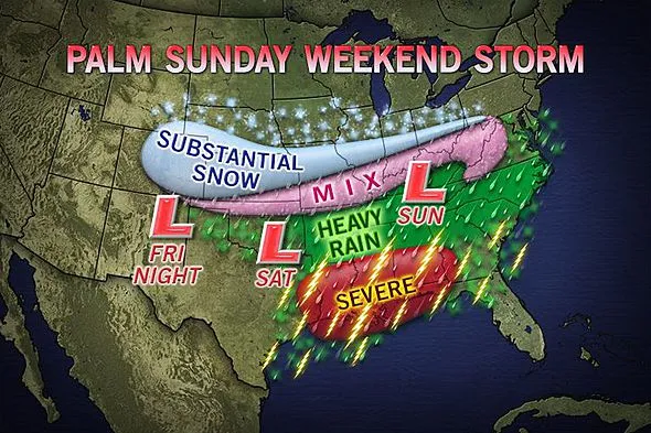
As a major storm tracks across the Central states, there is the risk of a severe weather outbreak from part of Texas to Florida that could reach as far north as the I-20 corridor.
Blinding downpours and flooding could disrupt travel and foil outdoor activities during the Palm Sunday weekend. However, there is the potential for more violent weather conditions that could threaten lives and property from Houston to New Orleans and Tallahassee.

A surge of warmth and humidity from the Gulf could hit at the wrong time. A storm system will travel from west to east across the central Plains to the Ohio Valley. A batch of strong winds high in the atmosphere will also move from west to east, but a bit farther south, from northeastern Texas to Louisiana, Mississippi, Alabama, northern Florida and southern Georgia, during the surge of warm, moist air.
Thunderstorms will fire in the western areas aforementioned Friday, but widespread severe weather is not likely to unfold until Saturday.

The storms are likely to be at peak late Saturday into Saturday night while centered over the Mississippi Delta region. These severe storms are likely to move quickly and would finish up Sunday along part of the southern Atlantic coast.
According to Severe Weather Expert Henry Margusity, "The greatest risks from the storms are large hail, damaging winds and flash flooding. However, provided the right conditions develop, isolated mature storms could yield a few tornadoes."
Get the world’s most fascinating discoveries delivered straight to your inbox.
This is the type of situation where such storms could form or linger after dark, adding to the danger.
Cities that could be in the path of the storms include Port Arthur, Texas; Shreveport, La.; El Dorado, Ark.; Montgomery, Ala.; Jackson, Miss.; and Columbus, Ga.
Early indications are that a wedge of chilly air from the Ohio Valley to the Appalachians and along the central Atlantic coast will deter severe thunderstorms, but that chilly air could bring heavy rain and wintry precipitation to part of the area.
RELATED: Thursday Snow for Kansas City, Ozarks Major Storm Potential Palm Sunday Weekend Growing Season Outlook for 2013: Better for Corn, Other Crops
Additional information and updates will be made available as soon as possible on AccuWeather.com through the weekend, as far as the timing, areal coverage and nature of the event.
© AccuWeather.com. All rights reserved. More from AccuWeather.com.
The only sure thing about weather forecasts is that they’re wildly different all over the planet. Test your knowledge on the wild ranges in temperature, precipitation and more.
Extreme Weather Facts: Quiz Yourself
