
 Live Science Plus


Lake-Effect Snow Machine: Feet of Snow Next Week
This article was provided by AccuWeather.com.
Heavy, lake-effect snow will develop on Sunday as bitterly cold, howling winds whip across the unfrozen Great Lakes.
The cold winds gusting past 45 mph will follow a series of Canadian storms skirting across the northern tier of the U.S. into this weekend.

RELATED: Cold Waves and Canadian Storms Lash Northern US
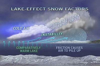
As cold air crosses the unfrozen and still relatively mild water of the lakes, there will be little friction over the open waters. This will cause the air to pile up and rise when it faces a higher friction over land, causing instability and snow showers.
A general 6-12 inches of snow will fall in the snow belts of the southeastern shores of the Great Lakes.
The typical lake-effect snow belts include portions of the Upper Peninsula of Michigan, northern and western portions of the Lower Peninsula of Michigan, northern Indiana, northeastern Ohio, northwestern Pennsylvania and western New York state.
Get the world’s most fascinating discoveries delivered straight to your inbox.
Dangerous travel will result the snow squalls with rapidly deteriorating roadway conditions. Extremely poor visibility will occur in heavy snow and blowing and drifting snow.
Meanwhile, AccuWeather RealFeel® temperatures will drop below zero at times.

Lake-effect snow will persist in some areas through next Wednesday.
"There's easily going to be a yard of snow some places where the lake-effect snow persists," AccuWeather Expert Senior Meteorologist Alex Sosnowski said.
The heaviest and most persistent snow will favor communities that get lake-effect snow on a northwestern wind.
For instance, a couple of feet of snow may come down on ski areas to the south of Buffalo, N.Y.
However, the snow bands will shift around on a couple of occasions so places that get the heavy lake-effect snow on southwest winds, including Buffalo and Watertown, N.Y., get in on the snow event.
AccuWeather.com. All rights reserved. More from AccuWeather.com.
With much of the country experiencing an unseasonably warm winter, fears of climate change come to mind. See how well you understand recent weather, climate and the difference between them.
Weather vs. Climate Change: Test Yourself
