Bitter Cold Drives Southwest Dust Storm


Just how cold is it in the Southwest? The answer, my friends, is blowin' all the way to Kansas.
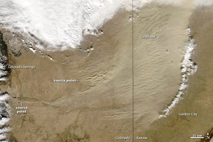
NASA's Aqua satellite spotted the bitter cold front now sweeping through the Rocky Mountains on Jan. 11. The descending mass of frigid air drove winds that scooped up dust in the Colorado Front Ranges and carried it through the air to Kansas. Cold, dense air wedging under warmer air can create strong wind gusts.
The dust was thickest in Kansas, but the source was the Arkansas River canyon in the foothills of the Rocky Mountains in Colorado, along with the river's tributaries.
One dust plume arose about 40 miles (70 kilometers) south of Colorado Springs, as seen in the natural-color image, snapped by the Moderate Resolution Imaging Spectroradiometer aboard the Aqua satellite.
In Kansas, the eastern edge of the dust storm spanned 150 miles (240 km) and the dust was thick enough to hide the land surface below, especially east of Goodland, NASA's Earth Observatory reported.
At the National Weather Service office in Goodland, the blowing dust reduced visibility to less than a mile, the NWS reported on its Facebook page. Gusts up to 60 mph (100 kph) from the southwest made travel hazardous throughout northwest Kansas and northeast Colorado, the NWS said.
The dust storm was exacerbated by severe drought conditions in the Southwest, the NWS told the Salina Journal. The 2012 drought is the worst observed since the U.S. Drought Monitor began operating in 2000, and drought remains a concern for the Southwest in 2013, according to the National Oceanic and Atmospheric Administration.
Get the world’s most fascinating discoveries delivered straight to your inbox.
As the dust settles and is washed to the sea, the cold front is marching eastward. The mass of cold air will drop temperatures in the Midwest and the East Coast later this week while the West Coast sees warm weather return, forecasters say.
Reach Becky Oskin at boskin@techmedianetwork.com. Follow her on Twitter @beckyoskin. Follow OurAmazingPlanet on Twitter @OAPlanet. We're also on Facebook and Google+.


 Live Science Plus


