
Space photos remind us that, around every corner of our vast universe, something spectacular awaits. From the newest James Webb Space Telescope images to historic photos of groundbreaking space missions, join us every Sunday as we explore the wonders of the universe, and humanity's place in it.
See more incredible space photos:

-
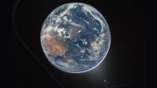 Artemis II crew's iconic view of Earth shows simultaneous auroras over both poles
Space photo of the week The four astronauts on NASA’s Artemis II mission captured more than they bargained for when they photographed the nightside of Earth, right after starting their historic journey to the moon.
Space photo of the week -
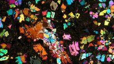 Ultra-rare meteorite could be evidence of a lost planet that once orbited near Earth — Space photo of the week
A rare meteorite found in the Sahara Desert may be evidence of a long-lost "protoplanet" that formed in the early solar system before being destroyed in a colossal collision, a new study suggests
7 Comments -
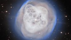 Astronomers gaze into the 'Crystal Ball Nebula' and see a vision of the sun's death
The Crystal Ball Nebula has captivated astronomers for more than 200 years, and it offers a bittersweet glimpse of a dying star system similar to our own.
-
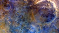 Mars looks blue and bruised in surreal new images from Psyche spacecraft — Space photo of the week
On its way to a metal asteroid, NASA's Psyche probe tested its cameras as it got a gravity assist from the Red Planet.
-
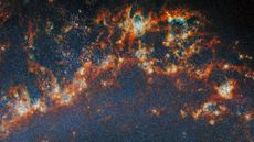 Webb and Hubble sink deep into the dazzling Whirlpool Galaxy — Space photo of the week
A striking new image of the Whirlpool Galaxy is helping astronomers solve one of the biggest mysteries in star formation.
-
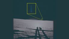 Declassified Apollo 12 images show UFOs on the moon — Space photo of the week
Newly declassified images from the Apollo 12 mission highlight strange, unidentified lights spotted by astronauts on the moon.
26 Comments -
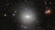 Scientists detect an enormous halo around the iconic Sombrero Galaxy — Space photo of the week
The 570-megapixel Dark Energy Camera in Chile has captured an extended halo and a dust-filled disk around the hat-shaped Sombrero Galaxy.
-
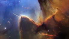 Hubble revisits stunning Trifid Nebula after 30 years, and spots a growing jet of energy — Space photo of the week
The Hubble Space Telescope revisits a star-forming region 5,000 light-years from Earth, which it first captured in 1997, revealing how the cosmic nursery has changed over human timescales.
-
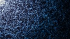 Largest-ever 3D map of the universe shows 47 million galaxies, from the Milky Way to 'cosmic noon' — Space photo of the week
The largest 3D map of the universe, created with data from the Dark Energy Spectroscopic Instrument, shows 47 million galaxies in stunning detail.
32 Comments


