An earthquake of preliminary magnitude 6.3 struck today off the coast of Southern California, according to the U.S. Geological Survey (USGS).
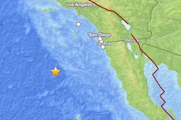
The temblor's epicenter was 172 miles (277 km) southwest of Coronado, Calif., (just outside of downtown San Diego) and 163 miles (263 km) south-southwest of Santa Catalina Island. It originated 7 miles (11.3 km) deep and struck at 2:36 a.m. local time (1036 UTC), the USGS reports.
An aftershock of preliminary magnitude 4.7 followed 15 minutes later.
Latest Videos From
There was some light shaking felt in communities along the coast, from the Los Angeles area to Ensenada, Mexico. There were no immediate reports of damage and no tsunami warning was issued.
Though Southern California experiences frequent earthquakes along the San Andreas and associated faults, the spot where today's quake struck has not seen any temblors greater than magnitude 6.0 in the past 40 years, according to the USGS. The quake, which originated from within the crust of the Pacific plate, represents a rare intraplate earthquake, as opposed to more common interplate events that occur at plate boundaries.
Earthquakes of this size are sometimes considered major and can cause significant damage, especially with poorly built structures. Even well designed buildings can be damaged or, in some cases, destroyed depending on the severity of the quake and a building’s proximity to the epicenter. Earthquakes of this size are sometimes followed by significant aftershocks. But the damage caused by any single event depends on the quake's depth, proximity to populated areas, building standards in the region, as well as the type of earthquake. The USGS frequently updates the magnitude of an event after more data is analyzed.
An earthquake's magnitude is a measure of the energy released at the source. It is just one predictor of the shaking that may ensue, which is affected by local and regional geology. Scientists know in a general sense what causes Earthquakes but are unable to predict specific quakes.
This article will be updated if significant additional information becomes available. Find more earthquake news here.

 Live Science Plus