It's quick and easy to access Live Science Plus, simply enter your email below. We'll send you a confirmation and sign you up for our daily newsletter, keeping you up to date with the latest science news.
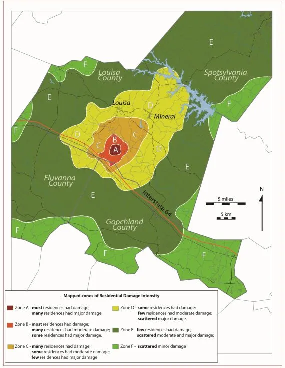
Last year's 5.8-magnitude earthquake that hit eastern Virginia caused a significant amount of damage to homes in the area, much of which was overlooked because it happened in a sparsely populated region. Researchers have created a new map showing the extent of the damage, presented earlier this month at the annual meeting of the Geological Society of America in Charlotte, N.C.
The earthquake destroyed up to seven houses and caused major damage to 120, said Matthew Heller, of the Virginia Department of Mines, Minerals and Energy. Major damage is defined as damage to the structural integrity of the house, such as the foundation, often requiring the house to be rebuilt.
Luckily, the quake didn't cause any major injuries or fatalities, and struck the least populated area of Louisa County, which isn't highly populated, Heller said.
The new damage map was compiled from reports by inspectors from the county and the Federal Emergency Management Agency, as well as reports from homeowners. Heller also visited many of the homes in the region to see the damage firsthand.
The most common type of damage was destroyed chimneys, he said. The quake also cracked foundations, crumbled walls and broke water lines that led to minor flooding, he added.
At first, the map of property damage didn't match the estimated epicenter, which was thought to be several miles to the east. But revised calculations, also presented at the meeting by a separate group of researchers, put the quake's epicenter about 4 miles (6 kilometers) to the southwest of the original location, which agrees well with Heller's map. "It all seems to be matching up now," he told OurAmazingPlanet.
"Most of the damage was to the west of the epicenter, because the earth moved up and to the west," he said. The quake was also felt by nearly a third of the U.S. population and shook the largest area ever recorded, causing landslides up to 150 miles (245 km) away.
Sign up for the Live Science daily newsletter now
Get the world’s most fascinating discoveries delivered straight to your inbox.
The nature of the crust under eastern North America determines how far an earthquake is felt. In the East, the crust is older, more consolidated and less broken up by faults than the crust under western portions of the continent. These characteristics mean that the energy from an earthquake travels more easily through the crust in the East.
A fallen chimney in Louisa County, Va., caused by the 5.8-magnitude earthquake that hit eastern Virginia on Aug. 23, 2011.
(Image credit: Virginia Department of Mines, Minerals and Energy)
A broken foundation in Louisa County, Va., caused by the 5.8-magnitude earthquake that hit eastern Virginia on Aug. 23, 2011.
(Image credit: Virginia Department of Mines, Minerals and Energy)
Douglas Main loves the weird and wonderful world of science, digging into amazing Planet Earth discoveries and wacky animal findings (from marsupials mating themselves to death to zombie worms to tear-drinking butterflies) for Live Science. Follow Doug on Google+.