Western Wildfire Smoke Spotted from Space

Get the world’s most fascinating discoveries delivered straight to your inbox.
You are now subscribed
Your newsletter sign-up was successful
Want to add more newsletters?

Delivered Daily
Daily Newsletter
Sign up for the latest discoveries, groundbreaking research and fascinating breakthroughs that impact you and the wider world direct to your inbox.

Once a week
Life's Little Mysteries
Feed your curiosity with an exclusive mystery every week, solved with science and delivered direct to your inbox before it's seen anywhere else.

Once a week
How It Works
Sign up to our free science & technology newsletter for your weekly fix of fascinating articles, quick quizzes, amazing images, and more

Delivered daily
Space.com Newsletter
Breaking space news, the latest updates on rocket launches, skywatching events and more!

Once a month
Watch This Space
Sign up to our monthly entertainment newsletter to keep up with all our coverage of the latest sci-fi and space movies, tv shows, games and books.

Once a week
Night Sky This Week
Discover this week's must-see night sky events, moon phases, and stunning astrophotos. Sign up for our skywatching newsletter and explore the universe with us!
Join the club
Get full access to premium articles, exclusive features and a growing list of member rewards.
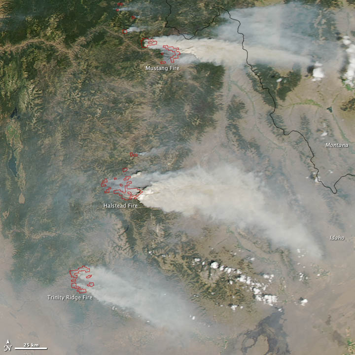
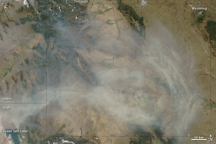
NASA's Aqua satellite captured an image of three major wildfires in Idaho and the thick smoke from the blazes, which is billowing over neighboring Wyoming, on Aug. 14.
In some places it is so thick you cannot see the ground, meaning people on the ground likely cannot see the sky.
The largest of the wildfires is the Halstead Fire, which as of today (Aug. 17) has already charred more than 131 square miles (339 square kilometers) and is only three percent contained, according to the National Forest Service. It was sparked by lightning in July, and is fueled by beetle-killed stands of lodgepole pine.
North of the Halstead Fire, a collection of wildfires known as the Mustang Complex has burned 125 square miles (323 square km). Those fires were 5 percent contained as of today. To the south is the Trinity Ridge fire, which has chewed through 113 square miles (293 square km) of Boise National Forest. Lightning ignited the Mustang fire while human activities started the Trinity Ridge blaze.
The second image shows smoke billowing over Wyoming, from fires in Idaho as well as California, Oregon and Nevada. Western blazes have reduced air quality throughout the country. Smoke plumes stretch from northern California eastward to the Upper Midwest and northward into Canada, according to the Smog Blog at the University of Maryland.
Over the western United States, smoke has mixed with ozone and prompted several air-quality alerts, according to the blog.
In the first image, red outlines indicate hot spots where wildfires are burning and increasing surface temperatures.
Get the world’s most fascinating discoveries delivered straight to your inbox.
Wildfires raged through Colorado and throughout the Southwest earlier this summer. Now the western states of California, Oregon, Nevada and Idaho are feeling the burn. Today, 35 fires blazed across the four states, burning through vegetation ranging from sagebrush to grass to the beetle-killed pine forests.
There are currently 16 blazes in Idaho, and a total of 57 large fires burning throughout the country, according to the National Interagency Fire Center. These blazes have charred 10,228 square miles (26,490 square kilometers). That's above the 10-year average for this date, which is 7,910 square miles (20,486 square km).
It's been a bad year for wildfires, partially due to the intense drought gripping much of the country.
Follow OurAmazingPlanet on Twitter @OAPlanet. We're also on Facebook and Google+.
 Live Science Plus


