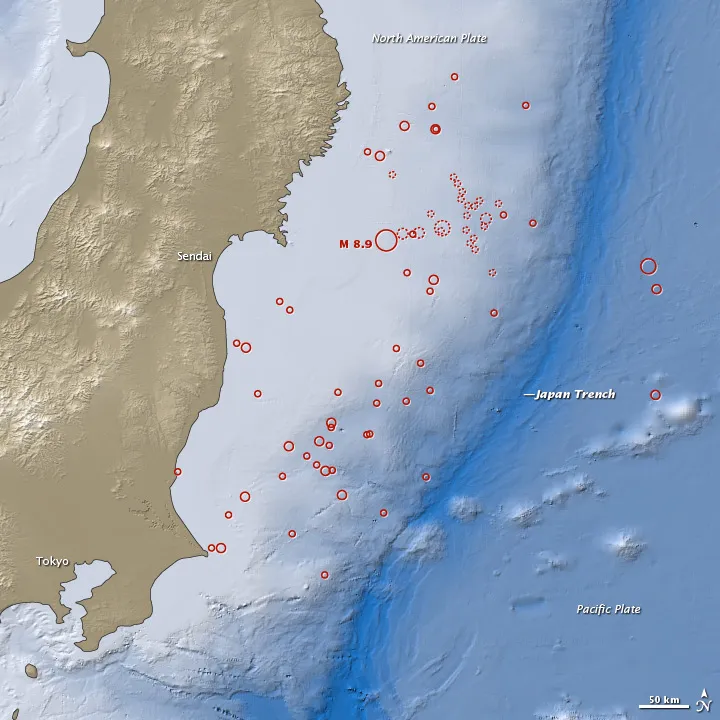
The deadly earthquake that struck Japan last week has been upgraded from an 8.9 to a 9.0-magnitude, the U.S. Geological Survey (USGS) announced today (March 14).
This magnitude places the earthquake as the fourth largest in the world since 1900 and the largest in Japan since modern instrumental recordings began 130 years ago, according to the USGS.
A 9.0-magnitude earthquake is about 1.4 times stronger than an 8.9-magnitude, said Susan Potter, a geophysicist with the USGS.
Latest Videos FromLive Science
The USGS often updates an earthquake’s magnitude as more data become available and more time-intensive analysis is performed. Japanese scientists had already upgraded the earthquake from an 8.8 to 9.0. The USGS noted that different agencies use different techniques to measure the magnitude of earthquakes.
The 9.0-magnitude earthquake struck at 2:46 p.m. local time (12:46 a.m. EST) on Friday (March 11) off the east coast of Honshu, Japan's largest island and home to about 100 million people.
The temblor ruptured 231 miles (373 kilometers) northeast of Tokyo and 80 miles (130 km) east of Sendai, Honshu, in the Pacific Ocean near the Japan Trench. The Japan Trench is a subduction zone, where the Pacific plate — beneath the Pacific Ocean — dives underneath the North American plate — beneath Japan. This violent movement, called thrust faulting, forced the North American plate upward in this latest quake.
The quake triggered a massive tsunami that socked Japan's coast, where the death toll is expected to exceed 10,000, according to news reports.
More than 150 aftershocks of magnitude 5 or greater have followed the massive quake, including more than two dozen of magnitude 6 or greater, and one aftershock of magnitude 7.1.
Email OurAmazingPlanet staff writer Brett Israel at [email protected]. Follow him on Twitter @btisrael.