
-
 Socotra Archipelago: The Yemeni islands covered with astonishing cucumber, bottle and dragon's blood trees
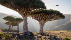
Incredible Places Socotra Archipelago in the Northwest Indian Ocean is home to hundreds of animal and plant species that aren't found anywhere else in the world.
4 CommentsIncredible Places -
 Fingal's Cave: Scotland's 'cave of melody' where eerie echoes bounce off pillars of solidified lava
Fingal's Cave is a hollow inside the Scottish island of Staffa that is characterized by massive, interlocking hexagonal columns of volcanic rock and astonishing acoustics.
3 Commentsgeology -
 Don Juan Pond: Antarctica's salty, syrupy lake that never freezes, even when it's minus 58 F
Don Juan Pond is a mysterious lake in Antarctica that contains so much calcium chloride, it doesn't freeze in subzero temperatures.
antarctica -
 Thríhnúkagígur: The only volcano on Earth where you can descend into a magma chamber
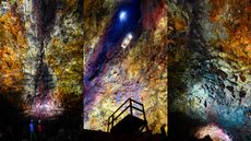
Thríhnúkagígur is a volcano near Reykjavík in Iceland with an empty magma chamber decorated with vivid colors that scientists and tourists can access via an open cable elevator.
4 Commentsgeology -
 Aoshima: Japan's tiny 'Cat Island' where felines hugely outnumber humans
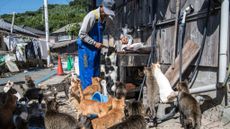
Once a thriving sardine fishing island, today Aoshima is home to roughly 80 cats and just a handful of people who look after the felines with the help of food donations from around Japan.
planet-earth -
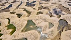 Lençóis Maranhenses: Brazil's dune-filled expanse that sits at the intersection of 3 biomes
Lençóis Maranhenses National Park hosts sand-dune fields that fill up with lagoons every wet season, but the reserve also has mangrove swamps where species such as the scarlet ibis thrive.
rivers-oceans -
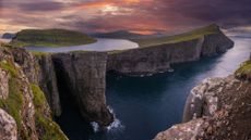 Sørvágsvatn: The lake that 'floats' above the ocean thanks to a unique optical illusion
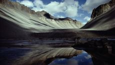
Sørvágsvatn, also called Leitisvatn, is the largest lake in the Faroe Islands. Viewed from a certain angle, one side appears to hover above the Atlantic Ocean.
rivers-oceans -
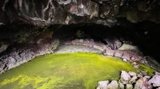 Bandera Volcano Ice Cave: The weird lava tube in New Mexico whose temperature is always below freezing
Due to a weird quirk of geology, New Mexico's Bandera Volcano Ice Cave never warms above 31 degrees Fahrenheit, even when temperatures outside exceed 100 F in summer.
2 Commentsgeology -
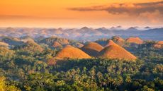 Chocolate Hills: The color-changing mounds in the Philippines that inspired legends of mud-slinging giants
The Chocolate Hills are 1,776 mounds on Bohol Island in the Philippines where grassy cover turns brown during the dry season.
geology


