An Antarctic mountain range that rivals the Alps in elevation will be probed this month by an expedition of scientists using airborne radar and other Information Age tools to virtually "peel away" more than 2.5 miles (4 kilometers) of ice covering the peaks.
One of the mysteries of the mountain range is that current evidence suggests that it "shouldn't be there" at all.
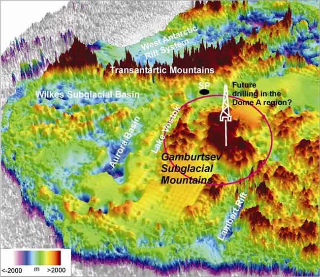
The researchers hope to find answers there to some basic questions about the nature of the southernmost continent, including the massive East Antarctic Ice Sheet. For instance, it is unclear how Antarctica came to be ice-covered in the first place and whether that process began millions of years ago in the enigmatic Gamburtsev Mountain range.
Latest Videos From
Working every day at extreme altitudes, in 24 hours of sunlight and at temperatures as low as minus 40 degrees Celsius, the researchers of the Antarctica's Gamburtsev Province (AGAP) team hope to learn whether the Gamburtsevs were born of tectonic activity in Antarctica or date from a period millions of years ago, when Antarctica was the center of an enormous supercontinent located at far lower latitudes.
Robin Bell of Columbia University's Lamont-Doherty Earth Observatory in New York, who shares the leadership of the U.S. science effort, said AGAP will help scientists understand one of Antarctica's last major mysteries.
"Because the heart of East Antarctica is so difficult to get to, we know very little about it," she said. "We think also that there's a strong possibility that the mountains are the birthplace of the East Antarctic Ice Sheet.
Over 30 million years ago ice began to grow around the peaks, eventually burying the range and its surrounding lakes.
AGAP involves researchers and support personnel from Australia, China, Germany, Japan, the United Kingdom and the United States. It caps the global scientific deployment known as the International Polar Year (IPY), the largest coordinated international scientific effort in 50 years.
The Gamburtsevs were discovered by a Soviet traverse during the last IPY in 1957-58 that was known as the International Geophysical Year (IGY). Since then the region has been largely untouched.
Traveling deep into the Antarctic interior, more than 390 miles (630 kilometers) from the South Pole, the science teams will be based at a pair of remote field camps while they complete the first major geophysical survey to map the mysterious landscape.
The U.S. research teams, from Columbia, Pennsylvania State University, Washington University in St. Louis, the Center for Remote Sensing of Ice Sheets at the University of Kansas, the Incorporated Research Institutions in Seismology and the U.S. Geological Survey, are supported by the National Science Foundation, which manages all U.S. research on the southernmost continent through the U.S. Antarctic Program. NSF also is the lead U.S. agency for IPY.
Aircraft supported by the NSF and the British Antarctic Survey, which is leading the United Kingdom's contribution to the AGAP effort, are specially equipped with ice-penetrating radar technology, gravimeter and magnetic field sensors and will fly survey lines over an area more than twice the size of California.
The scientists will eventually create a coordinated mosaic of images of the shallowest layers in the ice sheet to regions hundreds of kilometers beneath the hidden mountains, in effect creating a 3-D map of the vast and unexplored region, Bell said.
Researchers from Washington University and Penn State will contribute to the fieldwork by using seismic recordings of earthquakes to create images of the crust and mantle beneath the mountain range.
In addition to the scientists of the six participating nations, AGAP requires a total of nine aircraft, the establishment of two deep-field science camps, and support from the U.S. Amundsen-Scott South Pole and McMurdo research stations, as well as from the Australian Antarctic Davis Station and the British Antarctic Survey's Rothera Research Station.
Science and support teams on a Chinese tractor train from a base called Zhongshan Station to Dome A (the highest ice feature in Antarctica) will sample ice cores. Field depot camps and three other logistics support stations will ensure that food, fuel, supplies and equipment and people are in the right place at the right time.
"This project is a major undertaking for IPY," said Karl A. Erb, the director of the NSF's Office of Polar Programs. "No one nation could do this alone. International collaboration for both the science and logistics elements is absolutely essential."

 Live Science Plus