In the middle of Alaska, a great expanse of forested land bigger than California has remained quite mysterious — until recently.
NASA's Earth Observatory released a new high-resolution image of an Alaskan forest near the Tetlin National Wildlife Refuge that has been left off of most maps. Researchers are now trying to study the area, with the help of camera-equipped aircraft.
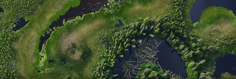
The photo, taken on July 10, shows a dense forest of black spruce trees surrounding nearby lakes. The bright-green color is mostly sphagnum moss. [Photos: Rare Glimpse of Remote Alaska]
"The U.S. Forest Service Inventory and Analysis program — the largest network of forest inventory plots in the world — does not include 450,000 square kilometers (174,000 square miles) of forest in the interior of Alaska, simply because it is so difficult to reach," Doug Morton, a scientist at NASA's Goddard Space Flight Center in Greenbelt, Maryland, told the Earth Observatory.
To map the hard-to-reach forests, Morton and a group of NASA researchers are sweeping across the Alaskan landscape in a low-flying airplane equipped with a portable imaging system called G-LiHT. G-LiHT can also measure the 3D distribution and composition of the different plant types that make up the forest, and it has thermal detectors that can examine surface temperature and any heat or moisture stress that can indicate drought. After the six-week mission, Morton and the team will combine ground measurements of the forest with the aerial data to create detailed maps of Alaska's forests.
The high-resolution images mean that individual trees can be spotted, and the forest does not appear as just a patch of green.
(Image credit: NASA Earth Observatory)
The plane hovers just 1,100 feet (335 meters) above the treetops and collects high-resolution imagery that satellites in orbit just can't capture. NASA's Landsat satellites, which have been snapping pictures of the Earth's surface for more than 40 years, now have instruments that can produce images with 49- to 98-foot (15 to 30 m) resolutions. But forests in Landsat images look like green paint strokes. G-LiHT can produce photographs at a smaller and sharper resolution: its images have a 4-inch (10 centimeters) resolution, and it captures other data at 3-foot (1 m) resolutions. For comparison, the clearest images on Google Maps have a resolution of 3 feet (1 m). From the G-LiHT images, researchers can pick out individual trees, rather than just a green smear.
Determining exactly what is growing in the forests, and studying the other measurements collected during the mission, could allow scientists to measure how the Alaskan forests are responding to climate change and increasing wildfire frequency.
Sign up for the Live Science daily newsletter now
Get the world’s most fascinating discoveries delivered straight to your inbox.
Kelly Dickerson is a staff writer for Live Science and Space.com. She regularly writes about physics, astronomy and environmental issues, as well as general science topics. Kelly is working on a Master of Arts degree at the City University of New York Graduate School of Journalism, and has a Bachelor of Science degree and Bachelor of Arts degree from Berry College. Kelly was a competitive swimmer for 13 years, and dabbles in skimboarding and long-distance running.