 Live Science Plus


This article was provided by AccuWeather.com.
The storm recently responsible for heavy rain in the Northwest will take aim at the northern Plains and perhaps the Upper Midwest, bringing not only the first snowfall of the season, but also the potential for a major storm.
Lingering warmth, colliding with a push of cold air from Canada and moisture will bring snow, rain and perhaps a severe weather outbreak.
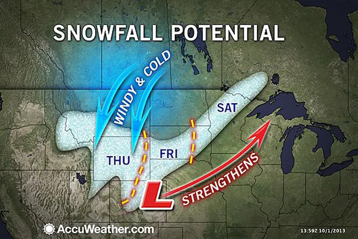
Cold air will wrap in behind the reorganizing storm across Montana, Wyoming and northern Colorado. The snow will fall on some areas hit by heavy snow last week. Heavy snowfall may be not limited to the higher elevations but could reach lower elevations in the region.

The storm will strengthen greatly over the northern Plains. As this happens, rain will become mixed with and change to snow in some locations.
Heavy snow could fall with gusty winds, from the Black Hills of South Dakota. Accumulating snow could reach eastward from the Black Hills to perhaps as far northeast as northern Minnesota. Travel along I-90 in South Dakota could be especially difficult late in the week if the storm develops to its full potential.
According to AccuWeather.com Winter Weather Expert Brian Wimer, "It would have to snow very hard over the northern Plains, away from the hills and mountains for an accumulations, but there is a chance of that at this point."
Accumulating snow may reach just north and west of Denver, Colo. Snow is likely in Cheyenne, Wyo.
If even a mere inch of snow falls in northern Minnesota, it would be unusual for the first week in October. The average first measurable snowfall in Duluth, Minn., is not until Oct. 24.
Measurable snow would not be unprecedented, however. The earliest measurable snow for a season in Duluth occurred on Sept. 18, 1991.
Across Colorado, some ski resorts are taking advantage of the cool weather and are already making snow. In preparation for the 2013-14 ski season, Loveland Ski Area and Arapahoe Basin Ski Area plan to make snow for as long as conditions allow, according to a press release by Colorado Ski Country USA (CSCUSA).
RELATED: Follow the Heavy Rain Across the Northwest Unusual Warmth For Minneapolis This Week Typhoon Pabuk Contributes to Northwest Flooding
Across southeastern Nebraska, Iowa and southern Wisconsin, the air will be too warm for snow, but powerful thunderstorms are a concern. Gusty winds will also be a factor.
@HenryMargusity tweeted: "The storm in the northern Plains Fri/Sat could have winds up to 60 mph and heavy rains, Severe weather will be in the Midwest."
More Relevant Tweets and Social Media Reaction
As high pressure builds in the wake of the storm over the West, a Santa Ana event could bring damaging winds and raise the risk of wildfires in Southern California late in the week.
As AccuWeather.com meteorologists predicted earlier this year, the fall season has started off wet in the Pacific Northwest.
Waves of downpours will continue to push into the Pacific Northwest through the middle of the week.
Moisture contributed by Typhoon Pabuk brought flooding rain events to the Northwest this past weekend. In addition to wind gusts in excess of 80 mph, parts of Oregon and Washington have been inundated by more than 4 inches of rain.
Expert Senior Meteorologist Alex Sosnowski contributed content to this story. © AccuWeather.com. All rights reserved. More from AccuWeather.com.
With much of the country experiencing an unseasonably warm winter, fears of climate change come to mind. See how well you understand recent weather, climate and the difference between them.
Pop Quiz: Sign of Climate Change, or Just Weird Weather?

