Luxor: Ancient Egyptian Capital
Luxor is a modern-day Egyptian city that lies atop an ancient city that the Greeks named “Thebes” and the ancient Egyptians called “Waset.”
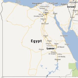
Located in the Nile River about 312 miles (500 kilometers) south of Cairo the World Gazetteer website reports that, as of the 2006 census, Luxor and its environs had a population of more than 450,000 people. The name Luxor “derives from the Arabic al-uksur, ‘the fortifications,’ which in turn was adapted from the Latin castrum,” which refers to a Roman fort built in the area, writes William Murnane in the "Oxford Encyclopedia of Ancient Egypt" (Oxford University Press, 2001).

The ancient city of Luxor served at times as Egypt’s capital and became one of its largest urban centers. “On the East Bank, beneath the modern city of Luxor, lie the remains of an ancient town that from about 1500 to 1000 B.C. was one of the most spectacular in Egypt, with a population of perhaps 50,000,” write archaeologists Kent Weeks and Nigel Hetherington in their book "The Valley of the Kings Site Management Masterplan" (Theban Mapping Project, 2006).

In ancient times, the city was known as home to the god Amun, a deity who became associated with Egyptian royalty. In turn, during Egypt’s “New Kingdom” period between roughly 1550-1050 B.C., most of Egypt’s rulers chose to be buried close to the city in the nearby Valley of the Kings. Other famous sites near the city, which were built or greatly expanded during the New Kingdom period, include Karnak Temple, Luxor Temple, the Valley of the Queens and Queen Hatshepsut’s mortuary temple at Deir al-Bahari.
“Of all the ancient cities, no other city reached the glory of Thebes in supremacy,” writes Egyptologist Rasha Soliman in her book "Old and Middle Kingdom Theban Tombs" (Golden House Publications, 2009). “Thebes is the largest and wealthiest heritage site in the world.”
Origins
Weeks and Hetherington point out that the area of Luxor has evidence of habitation going back 250,000 years. Soliman notes that during the Old Kingdom period (roughly 2650-2150 B.C.), the time the Great Pyramids were built at Giza, the ancient city at Luxor was a provincial administration centre.
It would take on new importance after the Old Kingdom collapsed, a time called the “first intermediate period.” During this period, the ancient city at Luxor became the capital of a local kingdom, one that in time succeeded in uniting the country.
The king who accomplished this reunification, named Nebhepetre Mentuhotep (who reigned about 4,000 years ago), is believed to have accomplished this feat in his 39th year of rule. Soliman notes that a mortuary temple for him was built near the city at a place called Deir al-Bahari. “The mortuary complex includes an unexcavated valley temple and a causeway 1,200 meters (4,000 feet) long,” writes Soliman. “It ended at the temple’s garden where statues of the king were placed.” The king’s tomb was located in the nearby hills and contains a passageway descending 490 feet (150 meters) into the ground.
Although Mentuhotep’s successors would move their court north, away from the city, construction at Karnak Temple appears to have picked up at this time.

New Kingdom renaissance
Construction near the city would flourish during Egypt’s New Kingdom period, between roughly 1550 and 1050 B.C. Most of the kings who reigned during this time chose to be buried in the nearby Valley of the Kings and a number of queens, princesses and princes were buried in the nearby Valley of the Queens. The pharaohs also built nearby mortuary temples and greatly expanded Karnak Temple. [Related: Ancient Shoes Turn Up in Egypt Temple]
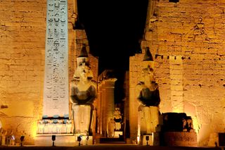
Luxor Temple, located on the east bank of the Nile River, was built to celebrate Egypt’s Opet Festival. “Most of the temple of Luxor in its present state was built by Amenhotep III (c. 1410–1372) in three phases,” writes Murnane. This temple would later be connected to Karnak through an avenue of “700 sandstone human-headed sphinxes,” writes a team of UCLA researchers working on the Digital Karnak project. This avenue ran for about two miles (3 kilometers).
During the Opet festival statues of Amun, Mut (his wife), Khonsu (their son) and the king were carried between the two temples writes Egyptologist Pat Remler in her book "Egyptian Mythology, A to Z" (Chelsea House, 2010). “When the procession reached Luxor Temple it was greeted with a joyous reception by various groups of dancers, singers and musicians,” she writes.
Home of Amun
While the city did serve as Egypt’s capital for parts of the New Kingdom period its use as a place for royal burials, and great temples, appears to be largely due to religious reasons.
The city was considered the home of the god Amun and so close was the relationship between this god and Egyptian royalty that Egyptian queens actually credited the deity with fathering their children.
“Amun was often credited by the queens of Egypt as having fathered their children. When Queen Hatshepsut came to power, she inscribed the story of her divine birth, from the union of Amun and her mother Queen Ahmose, on the wall of her mortuary temple at Deir al-Bahri (near the city),” writes Remler in her book.
Valley of the Kings
The Valley of the Kings was the burial place for most of the New Kingdom rulers. All of the royal tombs appear to have been looted to some degree with the most spectacularly well-preserved being that of King Tutankhamun, discovered by Howard Carter’s team in 1922.
The Valley of the Kings “was chosen as the burial place for most of Egypt's New Kingdom rulers for several reasons,” writes the Theban Mapping Project team on their website.
“As the crow flies, the Valley is very close to the cultivated banks of the river. It is small, surrounded by steep cliffs, and easily guarded. The local limestone, cut millions of years ago by torrential rains to form the Valley, is of good quality. And towering above the Valley is a mountain, al Qurn (‘the horn’ in Arabic), whose shape may have reminded the ancient Egyptians of a pyramid, and is dedicated to the goddess Meretseger.”
New tombs are still being discovered today with two, KV 63 and 64, being unearthed within the last decade. Additionally former antiquities minister Zahi Hawass said in a recent lecture at Toronto’s Royal Ontario Museum that there are more tombs yet to be found. "The tomb of Thutmose II, not found yet, the tomb of Ramesses VIII is not found yet, all the queens of dynasty 18 [1550-1292 B.C.] were buried in the valley and their tombs not found yet," he said.
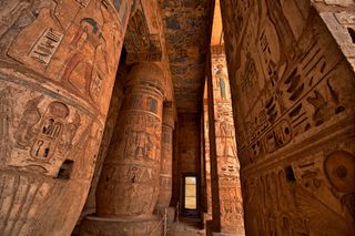
In addition to tombs the royal rulers built great mortuary temples close to the valley, the most well known of these mortuary temples was built at Deir al-Bahri by the female pharaoh Hatshepsut and contains three colonnaded terraces, which lead to a sanctuary. The temple’s decoration including scenes of the Egyptians voyaging to a distant land, probably located in Eritrea or southeast Sudan, called “Punt.”
Valley of the Queens
The Valley of the Queens, located near the Valley of the Kings, was known to the ancient Egyptians as ta set neferu “the place of the children of the king,” writes Alessandro Bongioanni, an adjunct professor at the University of Turin, in his book "Luxor and the Valley of the Kings" (White Star Publishers, 2004). It contained the tombs of princes, princesses, court dignitaries and, later on, queens, about 100 burials in all.
The more spectacular tomb is that of Nefertari, the wife of Ramesses II, the pharaoh who is known for the temples he built at Abu Simbel.
“Nefertari’s tomb, similar in structure to those of the pharaohs that have been excavated in the Valley of the Kings, presents an admirable example of refined relief painting on a white background that magnifies both its freshness and liveliness,” writes Bongioanni. The ceiling has astronomical motifs and on the walls “most of the iconographic and textual repertoire appears to have been taken from chapters of the Book of the Dead,” Bongioanni notes.
One particularly interesting illustration shows Nefertari playing a board game called “senet,” with “the aim of winning otherworldly salvation.”
Deir el-Medina
Located between the Valley of the Kings and Valley of the Queens is a village we call Deir el-Medina and which the ancient Egyptians called Set Maat “the place of truth.”
In this village “lived a number of civil servants, stonecutters, and draftsmen/artists who prepared the tombs of their kings and queens,” writes Leonard Lesko in the book "Pharaoh’s Workers: The Villagers of Deir el Medina" (Cornell University Press, 1994).
These skilled laborers, some of them foreigners, might have been what we would consider middle class. The place they lived in, however, did have a harsh environment. Deir el-Medina has no trees and the “barren hillsides that surround it reflect the heat of the desert sun on it,” writes Lesko.
This walled village was in operation until close to the time the New Kingdom ended and has yielded a number of papyri and ostraka, indicating that a sizable proportion of the population could write. The Guinness Book of World Records notes that it was the location of the first recorded workers strike in history which occurred during the reign of Ramesses III (reign 1186–1155 B.C.). The strikers were not the only ones unhappy with the pharaoh as recent research has confirmed that he was later assassinated.
— Owen Jarus, LiveScience Contributor
More Egyptian history:
Sign up for the Live Science daily newsletter now
Get the world’s most fascinating discoveries delivered straight to your inbox.

Owen Jarus is a regular contributor to Live Science who writes about archaeology and humans' past. He has also written for The Independent (UK), The Canadian Press (CP) and The Associated Press (AP), among others. Owen has a bachelor of arts degree from the University of Toronto and a journalism degree from Ryerson University.
