 Live Science Plus


Earth as Art: Arizona's Painted Desert
You are now subscribed
Your newsletter sign-up was successful
Want to add more newsletters?

Delivered Daily
Daily Newsletter
Sign up for the latest discoveries, groundbreaking research and fascinating breakthroughs that impact you and the wider world direct to your inbox.

Once a week
Life's Little Mysteries
Feed your curiosity with an exclusive mystery every week, solved with science and delivered direct to your inbox before it's seen anywhere else.

Once a week
How It Works
Sign up to our free science & technology newsletter for your weekly fix of fascinating articles, quick quizzes, amazing images, and more

Delivered daily
Space.com Newsletter
Breaking space news, the latest updates on rocket launches, skywatching events and more!

Once a month
Watch This Space
Sign up to our monthly entertainment newsletter to keep up with all our coverage of the latest sci-fi and space movies, tv shows, games and books.

Once a week
Night Sky This Week
Discover this week's must-see night sky events, moon phases, and stunning astrophotos. Sign up for our skywatching newsletter and explore the universe with us!
Join the club
Get full access to premium articles, exclusive features and a growing list of member rewards.
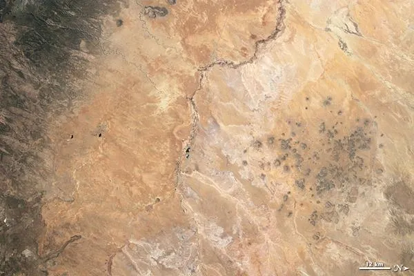
In northern Arizona lies an expanse of arid, erosion-prone badlands made of multicolored mudstones and clays. This Painted Desert stretches from the Grand Canyon in the northwest to the Petrified Forest National Park in the southeast.
On March 28, 2009, the Thematic Mapper on the Landsat 5 satellite captured two views of the Painted Desert. These images have been rotated so that north is at right.
The Thematic Mapper can sense parts of the light spectrum that our eyes cannot see. The bottom image provides a view made from these additional spectral bands, which are better at distinguishing between different types of rock, soil, and vegetation. The Thematic Mapper can also sense the amount of water in plants.
Whereas the natural-color view shows both rocky slopes in the north and vegetation in the south in about the same shade of brown, the false-color image shows these features in different colors. The more vibrant green in the south belongs to Sitgreaves National Forest. Running down the middle of the image, a serpentine line of green indicates vegetation along a river valley.

The false-color view of Painted Desert is part of the Earth as Art 3 online gallery from the U.S. Geological Survey.

